Dealing With The Aftermath Of Iowa’s Devastating Derecho
12:17 minutes
 This segment is part of The State of Science, a series featuring science stories from public radio stations across the United States. Read a story by Iowa Public Radio’s Kate Payne about the refugee families seeking shelter after the storm.
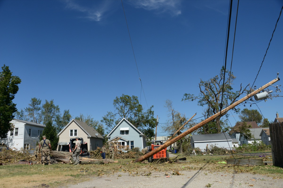
It’s been more than a week since the state of Iowa was hit by a surprise visitor: a line of thunderstorms with unusual power and duration, known as a derecho. The storms swept from South Dakota to Ohio in the course of a day. At its most powerful, the derecho hit Iowa’s Linn County and surroundings with hurricane-force winds amid the rain. Crops like corn and soybeans were flattened, while thousands of homes were damaged—if not completely destroyed.
Ira talks to Iowa Public Radio reporter Kate Payne and University of Northern Iowa meteorology professor Alan Czarnetzki about the devastating effects and unpredictable power of last week’s storm.
Good morning!☀️ Let’s talk Monday’s storms.
A long-lived, large storm complex tracked from the NE/IA border, across IA, northern IL, & northern IN. This produced widespread damage to trees, toppled several semis, & caused some structure damage.
Recap: https://t.co/AZJonw6Ykq pic.twitter.com/d7frOHNBhA
— NWS Chicago (@NWSChicago) August 11, 2020
Grain elevator smashed in Luther #iawx pic.twitter.com/eiCRlIWeJg
— Taylor Kanost (@WxKanost) August 10, 2020
I’ve been saying we need the rain but this is ridiculous #iowaweather #iowa pic.twitter.com/20hIArm2bt
— Andromeda (@Chillingchic) August 10, 2020
Invest in quality science journalism by making a donation to Science Friday.
Kate Payne is a reporter for Iowa Public Radio in Iowa City, Iowa.
Alan Czarnetzki is a meteorology professor at the University of Northern Iowa in Cedar Falls, Iowa.
IRA FLATOW: This is Science Friday. I’m Ira Flatow. It’s time to check in on the state of science.
SPEAKER 1: This is KERN.
SPEAKER 2: For WWNO
SPEAKER 3: St. Louis Public Radio.
SPEAKER 4: KKE News.
SPEAKER 5: Iowa Public Radio News.
IRA FLATOW: Local science stories of national significance. Last week, the Great Plains and Midwest had a surprise visitor, a powerful chain of thunderstorms known as a derecho. It started in the Dakotas, roared east over nearly 800 miles, eventually tapering off in Ohio. Derechos are not new. They can happen a couple of times a year in some parts of the country.
But this storm was unusually powerful. At the height of the storm, more than half a million people lost power. Hardest hit was the state of Iowa, where one county, home to the state’s second largest city of Cedar Rapids, is still reeling. A week after the storm, tens of thousands of residents of the state were still without power. More than 8,000 residential buildings were damaged or destroyed. And it all happened with almost no warning.
Here to talk more about the derecho’s aftermath and how it happened in the first place are my guests, Kate Payne, a reporter with Iowa Public Radio based in Iowa city– welcome to Science Friday.
KATE PAYNE: Thank you.
IRA FLATOW: And Dr. Alan Czarnetzki, a professor of meteorology at the University of Northern Iowa in Cedar Falls. Welcome to the program.
ALAN CZARNETZKI: Nice to be with you.
IRA FLATOW: Kate, you’ve been reporting daily on the aftermath of this storm in Iowa. But take us back, would you, to the day it came through. What was it like to experience the full force of this storm system?
KATE PAYNE: So Monday morning, this storm, ferocious storm, really caught so, so many Iowans off guard entirely. I’ve talked to multiple people who said they had a vague idea it was supposed to rain maybe that afternoon, but absolutely nothing like what we saw. Some of the latest estimates from the National Weather Service is estimates of wind speeds of up to 130 miles per hour. That’s comparable to a category 4 hurricane.
There were warnings that were coming down from the National Weather Service, from TV meteorologists saying this is a severe storm. But so many people had no idea– no idea what they were in for. At one point, in Linn County, one of the hardest hit counties, 97% of people were out of power in that county.
IRA FLATOW: Wow.
KATE PAYNE: There was no cell service, no internet of course, no power. Some buildings, the roofs are entirely peeled off of the buildings while people were trapped inside. So far, we know of three deaths in the state from this storm. We still don’t know how many people have been left homeless. And hunger is a real issue. We’ve heard lots of stories of people also struggling to get insulin, to get diapers for their babies. It’s been incredibly difficult for people here.
IRA FLATOW: And you went out and reported and talked to people on the scene.
KATE PAYNE: Yeah, and one of the people that I met is a man named Kobinali Muishi, and he lives in an apartment complex that is primarily home to refugees from all over the world. He was at work when the storm hit, but his pregnant wife and their two children were inside the apartment complex on the top floor. The roof was entirely torn off around them. He told me he thought that his entire family was going to die that day.
SPEAKER: Seriously, it was bad day. I can never forget that day. I was like, I’m going to lose all my family.
KATE PAYNE: His wife actually gave birth to their newest child two days after the storm, which is incredible, but that they’ve lost absolutely everything they own. He told me, this is what I own, the clothes on my body, a few diapers, and that’s it.
IRA FLATOW: And this came during prime crop growing season, did it not?
KATE PAYNE: Yeah. And we know something like 10 million acres of crops have been destroyed. The images are incredible, corn stalks totally snapped, flattened, and enormous grain bins crushed like aluminum foil, just crumpled with grain spilling everywhere. And that, of course, will have incredible long-term economic impacts on the state. But certainly, the immediate impacts is the humanitarian crisis that is happening here.
IRA FLATOW: Alan, how is a derecho different from twisters or even severe thunderstorms?
ALAN CZARNETZKI: Well, a derecho is a type of what we call a mesoscale convective system. Mesoscale means middle in size. And so they’re smaller than a low pressure system that might produce a snow storm, for example, but they’re bigger than an individual thunderstorm. You can get strong winds near the surface for a variety of reasons. The gustiness of the wind on a summer afternoon, for example, is produced by rising and sinking thermals of air. What they do is they tend to push faster winds above us down to the surface.
But another way that you can get strong winds near the surface, and this is peculiar to thunderstorms, they’re produced by air that is falling downward because of precipitation that’s dragging that air downward. And so when that air hits the ground, it’s redirected sideways, much like you take a garden hose. The stream of water, pointing it down at your driveway, when the water hits the ground, it doesn’t simply stop, but it gets redirected out sideways.
The leading edge of that advancing really fast wind is what we refer to as a gust storm. And gust storms are common to most all thunderstorms. But again, in the case of a derecho, that gets enhanced by environmental conditions that are on a particular side of the first thunderstorms.
IRA FLATOW: But most thunderstorms eventually peter out much faster, or the squall line moves through and they’re over with. How did this one move so far and stay strong for so long?
ALAN CZARNETZKI: Well, it did start out as somewhat benign-looking thunderstorms over south-central South Dakota. They slowly started to move east. The initial storms kind of dissipated, but they did go on to produce some severe thunderstorm warnings at about 2:50 in the morning. But they for the most part were looking somewhat ordinary. They were holding together. They were getting bigger.
The winds on August 10th were fairly uniformly out of the west as you go from the surface upward. And so the thunderstorms were being directed or steered along by those upper level winds. And as the storms moved along, they started to run into more and more favorable weather conditions that not only kept them going but caused them to intensify.
IRA FLATOW: That’s really interesting, because I would have suspected that there would be more tornadoes. There was only one little tornado in the whole system, and not even in Iowa. Why did we not see this form into tornadoes?
ALAN CZARNETZKI: The ingredient that tornadoes really need is strong wind shear. What that means is that the wind speed and direction changes dramatically when you go from the surface upwards. And the best way to get strong winds in the upper atmosphere is to have the jet stream in the vicinity. The jet stream meanders north and south over the course of a year’s time.
And generally speaking, in the summer, that flow has drifted more poleward. So it tends to be in southern Canada. Our winds aloft or not especially strong, and without that strong wind shear, it’s more difficult to generate tornadoes. So it wouldn’t be unexpected that this system really didn’t have much in the way of tornadic thunderstorms, and yet it produced a surprising amount of damage.
IRA FLATOW: Kate, I know you have a background that includes reporting in Florida, which is hurricane country. And I noticed when you compared, your analogy was to a hurricane.
KATE PAYNE: Yes.
IRA FLATOW: Is it fair to compare the kind of damage Iowa saw to the aftermath of a hurricane? Or what was different? You’ve been in both places now.
KATE PAYNE: To me, when I first arrived in Cedar Rapids and saw the destruction, I absolutely thought this looks like the aftermath of a hurricane. And if you go and watch some of the videos that people took from inside their homes as the storm blew through, it’s almost these whiteout conditions of this incredible wall of wind blowing rain, and you’re just seeing anything being blown apart.
One of the issues, I think, with this whole disaster is people’s lack of familiarity with the term derecho. I myself had never heard it before last week, and many Iowans as well were not familiar. And so a hurricane is a concept that people can grab on to and conceive of to explain just how much damage there is with, again, just a few hours of notice.
IRA FLATOW: That’s the other point I was going to ask. With a hurricane, we have all these hurricane watches. When you’re in Florida, you watch them come up the Caribbean for days in advance. And this gave almost no warning.
KATE PAYNE: Yes, and I think that’s part of why we’ve been seeing such a delay in the humanitarian response. The first overnight shelter was opened in Cedar Rapids on Friday. The storm hit on Monday. There was not enough notice for a storm like this, just because of its nature. With a hurricane, again, everyone has potentially days in advance. Governments can preposition utility trucks. Home Depot can send in generators. FEMA is aware of what is happening. We did not have that opportunity with this storm.
IRA FLATOW: Alan, do you think we’re going to see more derechos, and if so, do we need a better predicting formula for these?
ALAN CZARNETZKI: Well, I don’t know that we have a clear indication that there has been a change in the frequency of derechos. They have been around pretty much forever. As far as climate change, some of the conditions that we anticipate, the warming near the Earth’s surface, that alone would be a contributing factor in that it would tend to destabilize the air, and unstable air is very favorable for the production of strong updrafts and downdrafts and the damaging winds.
But other conditions that would result from warming probably are counterproductive. Generally, it’s thought that the faster winds in the atmosphere, the upper levels would shift more forward. And that wouldn’t necessarily then work in conjunction with the lower stability air at the surface. And so it’s a straightforward question, but something that has an uncertain and a complex answer.
And one of the challenges with these weather systems is that they can form both in the presence of what we would call weak forcing as well as strong forcing. Like people, sometimes exceptional storms are born from humble origins. And that did seem to be the case with this particular storm. Another challenge is in their early stages, they often resemble other types of convective weather systems.
KATE PAYNE: And it’s my understanding, Alan, part of the definition of a derecho is it has to travel so far at a certain intensity. And so definitionally, it’s something that you can only recognize after it’s happened.
ALAN CZARNETZKI: Exactly right. It’s an example of a weather system that’s not born with that identity. They start out as more ordinary thunderstorms, and many of them turn out to produce very little damage. But rather, this is something that, again, taps into conditions that just cause that down-burst wind to get focused in a particular channel, and you end up with the kind of damage that we saw.
IRA FLATOW: Well, I want to thank both of you for taking your time to talk with us about this. Kate Payne, a reporter with Iowa Public Radio based in Iowa City, Dr. Alan Czrnetzki, a professor of meteorology at the University of Northern Iowa in Cedar Falls, thank you both for taking time to be with us today.
KATE PAYNE: Thank you.
ALAN CZARNETZKI: Thank you.
Copyright © 2020 Science Friday Initiative. All rights reserved. Science Friday transcripts are produced on a tight deadline by 3Play Media. Fidelity to the original aired/published audio or video file might vary, and text might be updated or amended in the future. For the authoritative record of Science Friday’s programming, please visit the original aired/published recording. For terms of use and more information, visit our policies pages at http://www.sciencefriday.com/about/policies/
Christie Taylor was a producer for Science Friday. Her days involved diligent research, too many phone calls for an introvert, and asking scientists if they have any audio of that narwhal heartbeat.
Ira Flatow is the founder and host of Science Friday. His green thumb has revived many an office plant at death’s door.