Grade Level
6-12
minutes
Multi-day
subject
Earth Science
Activity Type:
mud cores, sedimentation, runoff, tropical cyclone, hurricane
Mud. It may not seem terribly exciting, and most of us even go out of our way to avoid it. But mud is actually fascinating stuff. Why? Well, for one, studying mud can help us better understand various natural processes and phenomena. For example, the sediment in a layer of mud can shed light on the origin of the water that carried it. Mud from the sea floor can teach us about ocean acidification. And mud can even help scientists figure out when and where hurricanes struck in the past, long before humans were around to keep track of such things. In a sense, mud keeps a journal of events that happen on earth, but it’s up to us to decipher those “memories.”
In this activity, you will create a model of sediment collected from the Blue Hole by scientists and use it to interpret climate events that occurred in the region. The goal of this activity is to understand how scientists use indirect evidence to make inferences about what earth’s climate was like in the past.
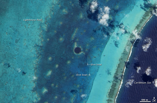
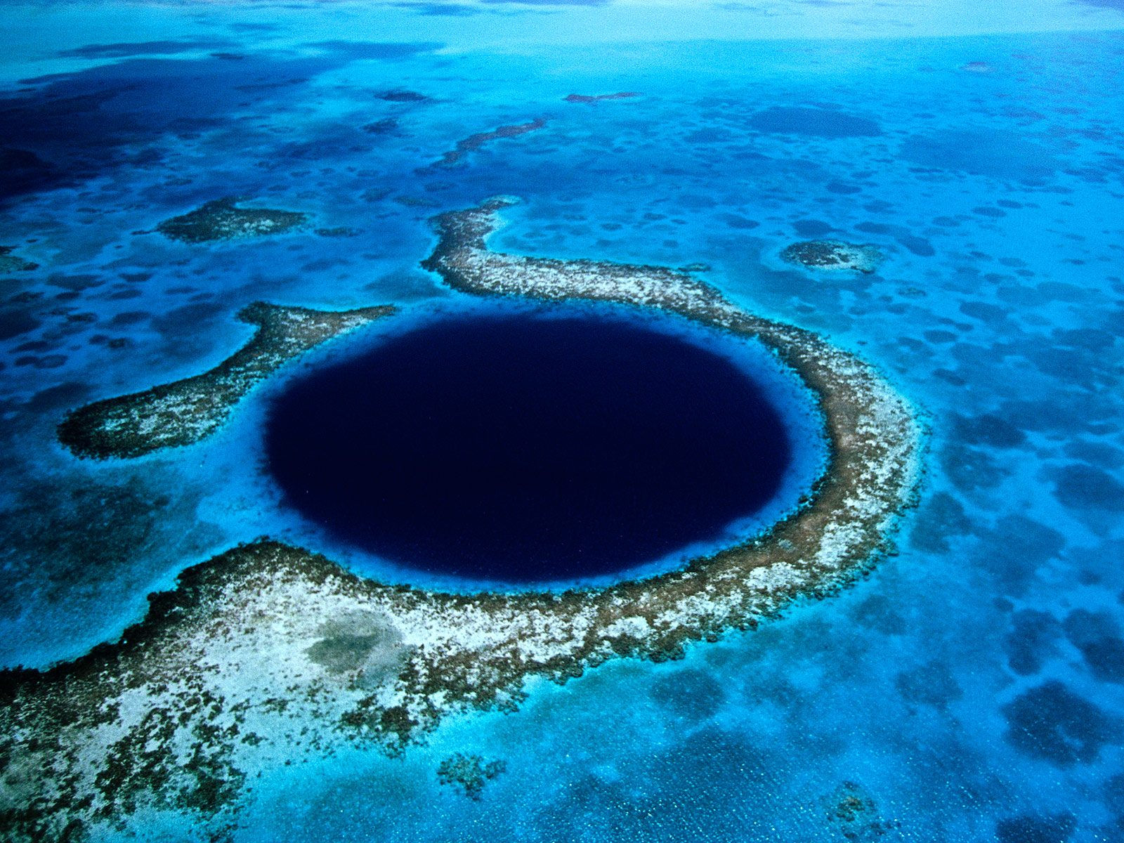
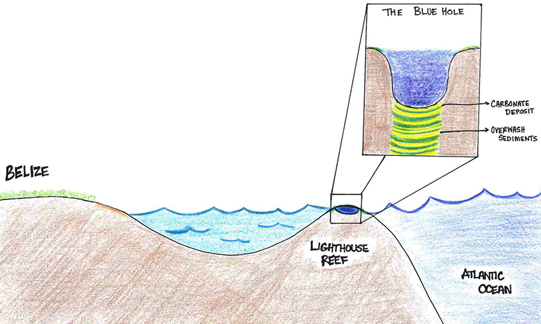
Belize’s Blue Hole Offers Clues To Mayan Collapse
How does mud hold memories?
Before attempting to glean information from mud, it helps to understand how mud forms in the first place.
When water—such as rain—falls onto the earth’s surface and flows over the ground, it is called surface runoff. Runoff, guided by topography and gravity, eventually flows into some larger body of water.
What might this water be carrying along with it?
Put some water in a jar and add 2-3 tablespoons of soil. Shake it up. Immediately after shaking, what do you notice about the soil in the water?
Just about all runoff, no matter where it’s headed, usually carries particles along with it. Most of these particles, which can include silt, soil, sand, and small rocks, are called sediment.
Look back at your jar of soil. What do you notice about the soil particles now? Do they stay floating in the water?
Most of the sediment that’s being carried along with the runoff will wind up in whatever body of water the runoff flows into. It doesn’t have much choice!
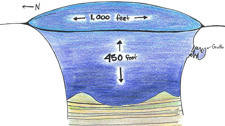
Let’s think about the Blue Hole. The mouth of the sinkhole is about 1,000 feet wide, and its depth plunges 450 feet. Over long periods of time, what will happen to the sediment as runoff flows into the sinkhole? Will it all mix together, or will it form layers, like a cake?
Most of the sediment winds up settling on the bottom, in the same order as it went in. As a result, different types of sediment form a sort of multi-layer cake.
How can memories in the sediment be retrieved?

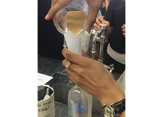
By digging into the sediment at the bottom of lakes, bays, marshes, and the ocean, scientists can determine what earth’s climate was like in the past. The process of collecting sediment is called coring. To collect a sediment core, researchers push a hollow tube slowly into the sediment (to keep the layers of sediment from moving) and, just as slowly, pull it back up. Then, they cut the core into shorter segments, halving each lengthwise, so they can study its layers.
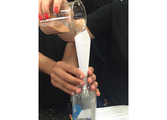
Create simulated sediment cores.
In this activity you will recreate, in four separate bottles, part of a sediment core taken from the Blue Hole. Classes should be divided into four groups, and each group will work on one bottle. After you have made your scale model, you will explore what kind of “memories” are stored in the Blue Hole and use the model to create a timeline of weather events in the region. Building a sediment core will allow you to better understand how sediment can reveal clues about earth’s past climate.
Materials per experimenter/group
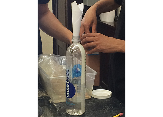
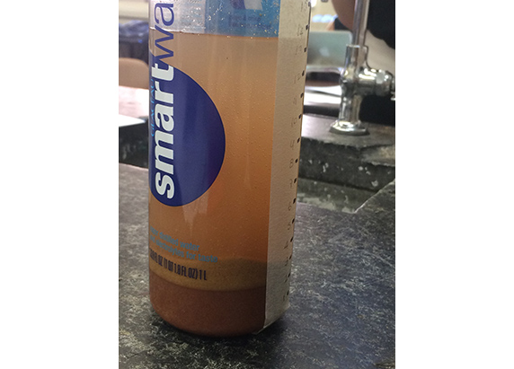
- 1 20-oz empty SmartWater bottle or another straight-sided, clear empty bottle (you’ll use this to construct a segment of the sediment core)
- 1 100-mL graduated cylinder
- Masking tape
- Ruler
- Two different types of sediment (soil, clay, silt, etc.) that are visually distinct (Note: The sediment in the “overwash” layers in the original core from the Blue Hole are much coarser than the sediment in the “carbonate deposit” layers.)
- Coarse sediment
- Finer sediment
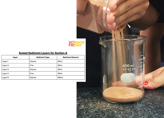
- Section of the Scaled Sediment Layer Sheet
- Sharpie marker
- Paper square or sheet
- Data and Observation Sheet
A note on your materials:
A SmartWater bottle was chosen to construct the sediment cores because its size and smooth sides mimic the shape of a core. The data from the original Blue Hole core has been scaled to suit this bottle (100 mL water in the bottle = 25 mm section of the original core). If a different bottle is being used, choose a flat-sided bottle. You will need to recalculate the scale.
Any available sediment may be used (e.g. sand, soil, clay), as long as each type is visually distinct. However, settling rates vary depending on the type of material used; if finer sediment is used, waiting longer than one day between adding layers is recommended.


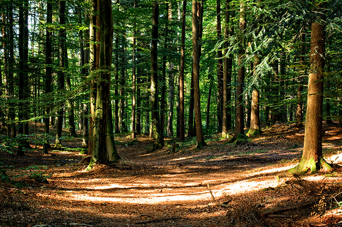
What kinds of sediment might you expect to find in runoff from a farm or forest?
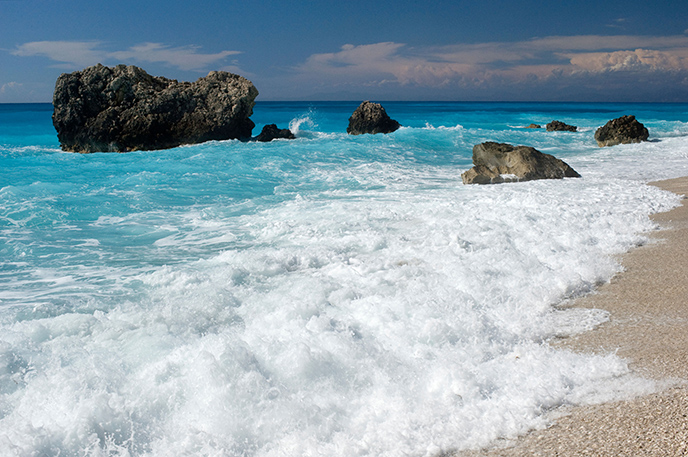
What kinds of sediment might you expect to find in the ocean?
The sediment in runoff varies widely depending on where the water came from. Runoff from a forest or farm might carry soil, as well as organic matter from decaying plants and bones of dead animals. Runoff from a city could contain metals, plastics, or chemical pollutants. The ocean carries sediment too; this is most likely to consist of sand, microscopic marine organisms, and broken bits of shells.
What might cause ocean sediment to be deposited in the Blue Hole?
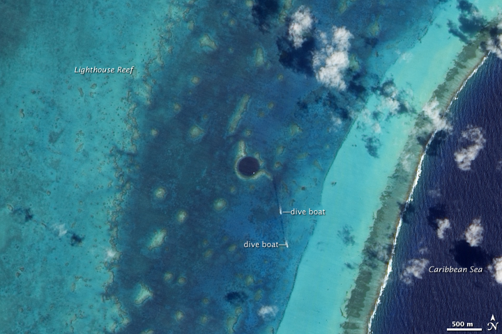
The mud layers in the Blue Hole contain two primary types of sediment: carbonate deposits, which are the remains of plankton and corals that lived on Lighthouse Reef, and overwash, which is sediment carried in the ocean that washed over the edge of the reef and into the Blue Hole.
What might cause the amount of sediment in runoff to increase or decrease?
The amount of sediment in runoff also varies widely. For example, imagine a large lake, and pretend that there’s a drought affecting the area surrounding the lake. The amount of runoff reaching the lake would be low, and the amount of sediment flowing into the lake would also below. This would result in a thinner layer of mud added to the layers on the bottom of the lake.
What might a thicker layer of lake sediment indicate?
How can sediment ‘remember’ hurricanes?
Now imagine a bay, separated from the ocean by a barrier island. Where would most of the sediment at the bottom of the bay come from? What kind of sediment would you expect to find?
Normally most of the mud at the bottom of the bay would come from the mainland, just like the sediment on the bottom of the imaginary lake, and each layer would be composed of similar sediment, forming a fairly homogenous mud pie.
What if this bay happens to be located in the tropics, and a hurricane is approaching?
If the hurricane is strong enough and generates a large enough storm surge, water from the ocean would flood over the barrier island and flow into the bay. The marine sediment (overwash) carried by the storm surge would eventually settle to the bottom of the bay, adding another, distinct layer to the bay’s particular mud pie.
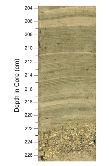
Look at a real sediment core from the Blue Hole.
The original Blue Hole sediment core (see image) is made up of carbonate deposits that slowly settled to the bottom of the sinkhole. These thin, grayish-green layers accumulated at about 2.5 mm/year. Interspersed with these fine bands of carbonate deposits are much thicker, lighter, coarser layers—marine sediment washed into the Blue Hole by passing hurricanes. It is important to analyze both the thickness and composition of the layers in a sediment core. The thickness can tell you something about past climate events, and the layer’s composition indicates the origin of the sediment.
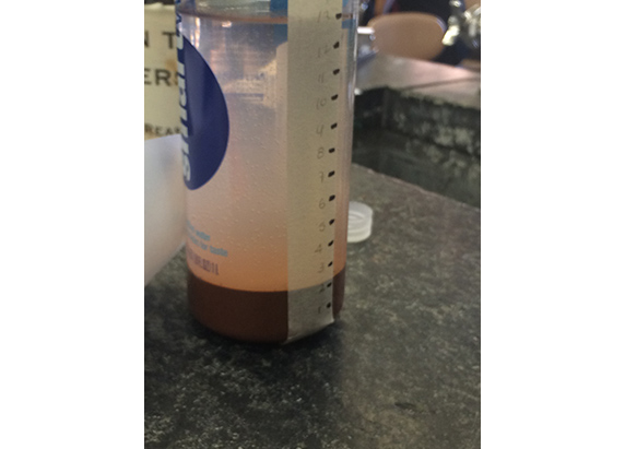
Using your Blue Hole sediment core models, identify evidence of past hurricanes.
Take a close look at the sediment models you created, and imagine that they came from a core taken from the Blue Hole.
- Which layers might represent sediment from a hurricane? Explain your reasoning.
- Identify how many hurricanes occurred in each of the four sections of your sediment core model.
- What might the thickness of a hurricane sediment layer tell you about the intensity of the hurricane? Why?
- Is the presence of a thick sediment layer in between thinner ones enough evidence to indicate that the layer was caused by a hurricane? Why or why not? What additional evidence might be needed to prove that the sediment came from a passing hurricane?
Assemble your simulated cores from youngest to oldest.
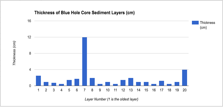
Each section of sediment core that you created represents part of a much longer core. You need to arrange the core sections in order from oldest layer to youngest layer. To do this, collect the “New Sediment Height (cm) data for all four sections (A-D) from other groups and record it on your Data and Observation Sheet. Using your data and the graph of sediment thickness below, try to arrange your four model sediment core sections in order, from oldest layer to youngest layer.
- What evidence supports the order that you put them in?
- In the complete sediment core model (all four core sections put together), how many hurricanes were there? How do you know?
- Do you think all of the hurricanes that affected this area of the Caribbean in the past are represented in the core? Why or why not?
- Say that a storm occurs that is strong, but that occurs farther away from the Blue Hole. How do you think that storm would affect the sediment record?
So what did the scientists learn about their core?
The composition and thickness of layers in the uppermost section of the original Blue Hole core (re-created in this activity) indicate that 10 tropical cyclone events occurred over the course of a 50-year period (from 1945 to 1996). (Tropical cyclones encompass both hurricanes and tropical storms.) The historical instrument record for the same time period documents 13 tropical cyclones passing within 100 km of the Blue Hole. Nine marine sediment layers in the core are closely correlated with the tropical cyclones that the historical record documents. These weather events varied in intensity from tropical storm (7 events) to Category 4 hurricane (1 event); the variations can be observed in the thickness of the marine sediment layers. Several storms documented by the instrument record are not reflected in the core; one reason for this could be that the storm wasn’t strong enough to generate a storm surge capable of washing ample sediment into the Blue Hole. What other reasons might there be for a “missing” layer in the core? There is also an “extra” overwash layer in the core that is not present in the instrument record. Where might this “extra” layer have come from?
The original Blue Hole sediment core is nearly five meters long, meaning it holds more than 1,000 years of data about tropical cyclone events. Why was it important for scientists to compare a section of the core with historical instrument records?
Related Topics/Extensions
- Hurricanes — data and lesson plan ideas from the National Hurricane Center
- Topography and bathymetry — data-based inquiry activities using GeoMapApp
- Paleoclimate proxies (tree rings, corals, ice cores, foraminifora, etc) — resources and lesson ideas from the Joides Resolution’s Deep Earth Academy.
- Water Cycle — USGS Water Cycle Resources
Resource Reference
Gischler, E., et. al. A 1500-Year Holocene Caribbean Climate Archive from the Blue Hole, Lighthouse Reef, Belize. Journal of Coastal Research; Vol 24, Iss 6; 2008.
Educator's Toolbox
Meet the Writer

About Samantha Adams
Samantha Adams is the twelfth-grade geoscience teacher at Pan American International High School at Monroe in the Bronx, New York. This is a specialized high school for Spanish-speaking immigrants who have recently moved to the United States.