Satellite Snapshots Help Pinpoint and Protect The Past
16:53 minutes
Indiana Jones makes archaeology look like a dusty, dangerous trade. But these days, with satellites canvassing the skies and sporting better cameras, modern-day treasure maps can be found right on your iPad—if you know what to look for.
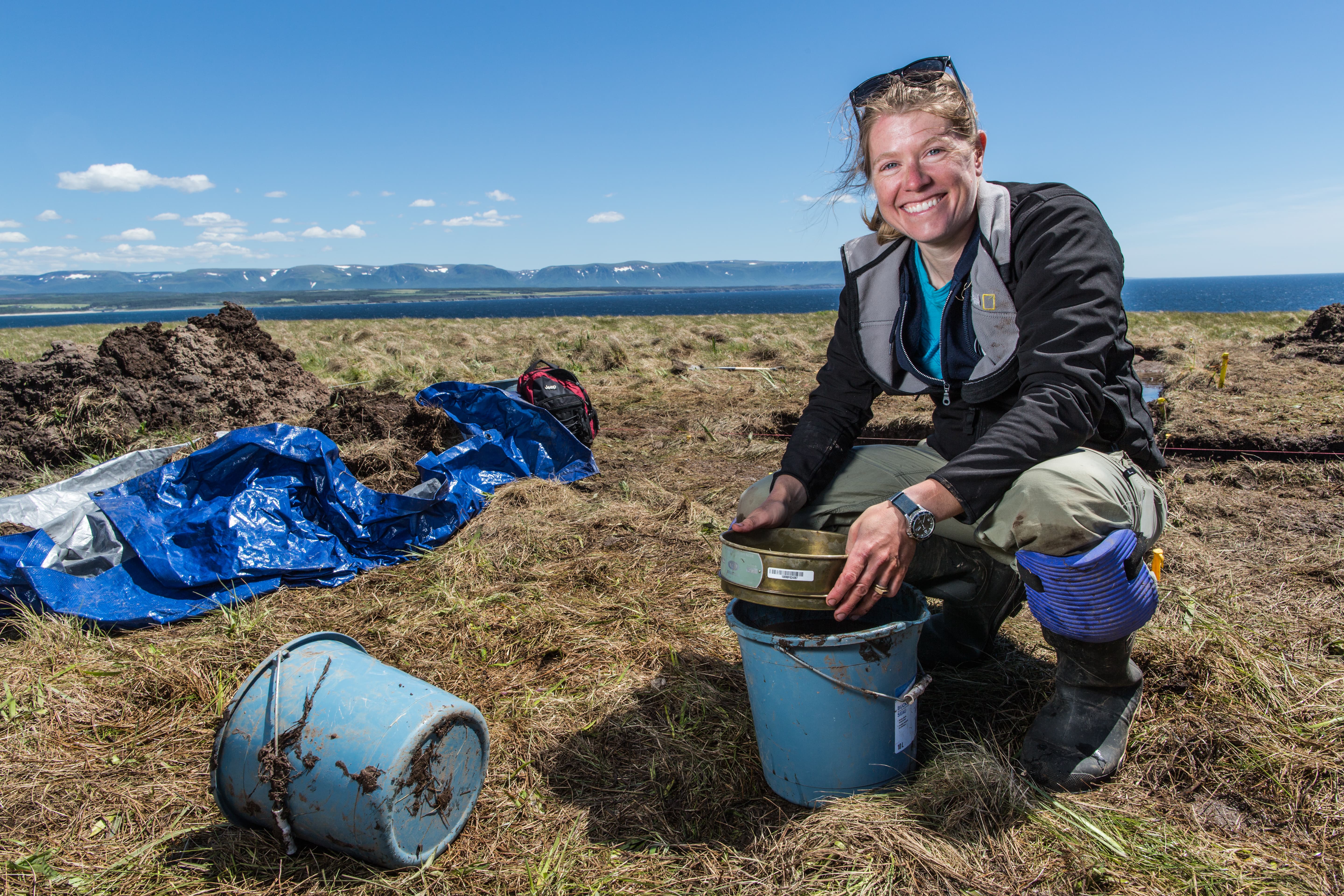
Sarah Parcak does. She’s a self-described “space archaeologist” who’s helped to uncover more than a dozen pyramids and 1,000 forgotten tombs in Egypt. Her latest satellite find is a potential Viking camp in Newfoundland—which would make it only the second-known settlement in North America.
Satellite snapshots can be used not just to pinpoint cultural heritage sites, but to protect them too. Susan Wolfinbarger, director of the Geospatial Technologies Project at AAAS, scans satellite imagery to track cultural crimes, like the looting and destruction of culturally significant sites in hard-to-access parts of the globe.
Note: Sarah Parcak stars in a two-hour PBS special on the science series NOVA, in a co-production with the BBC History Unit called “Vikings Unearthed.” It premiered this week on PBS—or check it out online at pbs.org/nova.
Susan Wolfinbarger is director of the Geospatial Technologies Project at the American Association for the Advancement of Science in Washington, D.C..
Sarah Parcak is a space archaeologist, National Geographic Fellow, and anthropology professor at the University of Alabama, Birmingham in Birmingham, Alabama.
JOHN DANKOSKY: This is Science Friday. I’m John Dankosky. You might think of archeology as a pretty dusty, pretty dangerous trade. At least, that’s how Indy makes it look. But these days, with satellites canvassing the skies sporting better and better cameras, modern-day maps to hidden tombs and treasures can be found right on your iPad if you know where to look.
Unfortunately, looters also can use Google Maps to find places to plunder– not without being watched, though, because all this satellite imagery also turns out to be a great way to track crime, to track illegal digs, destruction of cultural heritage sites, and human rights violations, too. Susan Wolfinbarger is director of the Geospatial Technologies Project at the American Association for the Advancement of Science in Washington, DC. Welcome to Science Friday, Doctor Wolfinbarger.
SUSAN WOLFINBARGER: Thank you. I’m really excited to be here.
JOHN DANKOSKY: We’re excited to have you. And Sarah Parcak is a National Geographic fellow and TED Prize winner, professor of Anthropology at the University of Alabama at Birmingham. Welcome back to Science Friday, Doctor Parcak.
SARAH PARCAK: It’s great to be back.
JOHN DANKOSKY: So Doctor Parcak, I will start with you. One of your latest finds is a possible Viking settlement in Newfoundland, which would make it only the second known settlement in North America. It’s pretty cool, right?
SARAH PARCAK: Yes. It’s early days. We have a lot more work to do before we’re able to determine whether or not it is a settlement. But everything is seeming to be very suggestive.
JOHN DANKOSKY: Looking at a regular satellite map of the area in Google Maps, I have to say I just can’t say it looks like there’s much there. What are you seeing? What are you looking at that we’re not seeing?
SARAH PARCAK: So we looked at the entirety of the eastern coast in Canada, kind of narrowed it down, and picked out a number of promising hotspots. And then for those areas, we got what’s known as multi-spectral satellite imagery. So vegetation grows on top of ancient remains. And the remains buried beneath the ground make the vegetation impossible to see or the health differences, they’re impossible to see in the naked human eye. And we have to process the data using the infrared to make those differences stand out.
JOHN DANKOSKY: OK. So that’s so interesting. So you’re essentially just looking at changes in plant life over all this time?
SARAH PARCAK: Yes. Yes, for this particular site.
JOHN DANKOSKY: My goodness. By the way, if you have any questions for our guests, 844-724-8255. That’s 844-SCI-TALK as we take a look at what we can see from the skies, Susan, you’ve been using satellite imagery to monitor cultural sites in Syria for about four years now. Has the situation there gotten quite a bit worse under ISIS? Or was destruction of some of these archaeological sites already under way?
SUSAN WOLFINBARGER: Well, we’ve been looking, as you said, for a number of years at the situation in Syria, since the Civil War began. And really, the destruction that we’re seeing has not been just an ISIS phenomenon. And that’s something I can’t say enough times. There was destruction happening across many sites long before ISIS entered the picture. There were encampments of, for example, Assad regime forces on some very well-known sites.
We were seeing signs of encampments on some of the tells, which are kind of higher areas. These archaeological sites are elevated above the surrounding landscape, so that makes them very good spots for military encampments. So we’ve seen a lot of damage happening across the entirety of the Syrian Civil War. And it’s not just a new phenomenon.
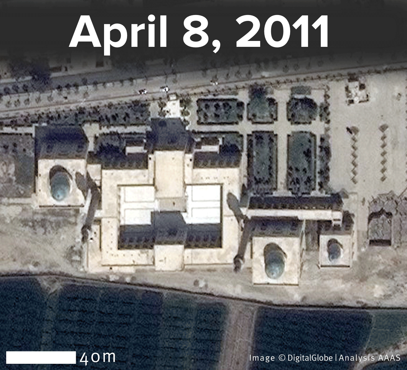
JOHN DANKOSKY: How bad has it gotten from your space-based based view at the ancient ruins there at Palmyra, something that we’ve all been watching from afar?
SUSAN WOLFINBARGER: Well, Palmyra, as you know, was recently taken back by the Assad regime with the help of the Russian forces. And Palmyra was in control by the Syrian government. And there was some damage that we saw there– as I said before, encampments and things on the site itself. So there was some damage to start with.
And then, of course, we’re all very aware of all the tragic events that happened on the site while ISIS was in control– the destruction of the Temple of Bel and Baalshamin and the destruction of the arch and, of course, the tragic beheadings and things that are happening there. And so, you know, there’s been quite a bit of damage that’s happened at Palmyra over the past few years.
JOHN DANKOSKY: Sarah, over your career you’ve also seen evidence of tomb raiding, illegal digs– stuff like the stuff that Susan is talking about. What happens when you see that? As is there any recourse? And what happens next when you see something like this?
SARAH PARCAK: So it’s interesting what Susan just said talking about all of the damage and how it just didn’t start with ISIL. We’ve used primarily open-source satellite data and looked at looting across the entirety of Egypt at every site going back to 2002. And what we found is that the looting didn’t really get much worse after the Arab Spring. It actually started in 2009 after the economic recession.
So what we’re doing with all this data– we have evidence for looting at 267 sites. We’re sharing that with the Egyptian government just because they don’t have a comprehensive monitoring system. And by giving them that data and showing them exactly where the looting is going on, they can then allocate resources and direct efforts to protect sites on the ground.
JOHN DANKOSKY: It sounds, Susan, like what you’re both doing is kind of countering some narratives that we had in the press over what’s happening and when.
SUSAN WOLFINBARGER: Yes, definitely. That is one of the great things that we can do with satellite imagery because, you know, it’s a very respected type of scientific analysis. It’s date stamped. It’s location specific. And so we’ve use that in a number of different ways to counter propaganda that’s going on.
For example, we used it during the conflict between Russia and Ukraine. When Russia was saying that they weren’t moving troops to the border, we were obtaining satellite imagery that was actually showing massive troops moving towards the border. So it’s really great for being able to say, no. This is actually what’s going on.
JOHN DANKOSKY: So one question I have is, Susan, why are you doing this? And why isn’t, I don’t know, the UN doing this instead?
SUSAN WOLFINBARGER: Well, the UN does do some of this, actually. They have a team called UNOSAT. And they work specifically for UN agencies. But I think it’s important that we do this at AAAS. We’re an independent scientific nonprofit.
And so a lot of the information that we’re able to distribute is seen as more– it’s equally scientific but less biased. And, you know, we’re coming at it from just a purely scientific and documentation point of view. So I think that people find our analysis to be slightly less controversial than the analysis that comes from different groups that have very specific agendas.
JOHN DANKOSKY: Sarah, when did satellite data become good enough to use in the way that you and Susan use it?
SARAH PARCAK: So high-resolution satellite sensors started being available in the late 1990s to early 2000s. But at that time, they were incredibly expensive. To get a single high resolution image of, say, a 5 by 5 kilometer area could be $5,000 to $10,000 whereas now the satellite data costs between $10 and $20 per square kilometer. So while it’s not free, it’s certainly very much in the realm of affordability for archaeologists and anthropologists and people who are working in humanitarian efforts.
JOHN DANKOSKY: And is this getting better all the time? Is the technology rapidly advancing as far as what you can see and how clear the picture is?
SARAH PARCAK: Oh, yes. It’s incredible. So I work a lot with a company called DigitalGlobe. They provide most of the high-resolution satellite data I use. And they just launched a new satellite sensor called Worldview 3. And from hundreds of miles in space, you can zoom in and see things as small as 10 inches. The resolution is 30 centimeters.
So I joke with my students, it’s almost like we’re cheating. We can really, from space, see anything from a tiny wall to a small feature. And that resolution is only going to be getting better and better as time goes on.
JOHN DANKOSKY: Now, Susan, tell me how that helps to your work– the ability to see something so, so small from so far up?
SUSAN WOLFINBARGER: Well, it’s great for us because a lot of the work that we do is in non-permissive environments. We work in a lot of conflict zones. We work in documenting things that are happening in countries where the governments probably don’t want to let us come in and investigate. So for example, we’ve used satellite imagery to look for mass graves. We look at attacks on civilians, housing demolitions– a whole range of different human rights related issues.
And so the satellites give us an ability to look in on what was happening. And because every time one of these images is collected it goes into an archive, we have this growing set of imagery that we can look at and, you know, build cases over time and understand what’s happening. And so it’s really phenomenal, just over the past 10 years, the amount of imagery and the amount of requests.
So my team often takes requests from human rights organizations to help them with documentation. And so now, almost every time someone comes to us with a request, we can help them out. And we can get satellite imagery to document the things that they’re interested in where, when I first started doing this work, it was really sad that, a lot of times, you would have to turn people down because there just wasn’t data that was available.
JOHN DANKOSKY: Well, can you tell us more about how you’re able to do humanitarian monitoring and track human rights violations?
SUSAN WOLFINBARGER: Sure. A lot of work that my team is doing has recently been focusing on international litigation and prosecutions– so, for example, providing evidence to the European Court of Human Rights or the International Criminal Court because they’re really looking for ways to improve the provision of evidence and do not rely as much on just eyewitness testimony because there’s been instances where eyewitnesses have disappeared or they’ve been intimidated into not testifying. So by being able to provide more scientific evidence, they’re able to build much stronger cases. So that’s one of the really great ways that we’re able to improve some human rights documentation with the technology.
But we also partner with a lot of small groups that are working all around the world. And we’ve looked at just tons of different things. We’ve done oil spills. And just it’s amazing the things that you can– the questions that you can answer that you didn’t even know you could answer once you start digging and exploring what the options are.
JOHN DANKOSKY: We’re going to take some phone calls here. Zack is calling from Auburn, Alabama. Hi, Zack. Go ahead.
ZACK: Hi. I have a question for Doctor Parcak. I was recently speaking with one of her colleagues except this person is at University of Alabama in Huntsville as opposed to Birmingham. And he mentioned that he was, at one time, looking for ruins out in the middle of Guatemala for the Mayans. And he stumbled across a pipeline. So I was wondering, what’s the most random thing that she has stumbled across while looking for ruins?
SARAH PARCAK: [LAUGHS] That’s a great question. I think you were probably talking to my colleague and friend Doctor Tom Sever. I call him the father of space archeology. He’s one of the real pioneers of using this for archeology. You know, this really shows you how important it is to go out in the field. We call it ground truthing.
You think you’re seeing something from space. And sometimes it’s obvious– it’s a certain rectilinear form, and it’s a certain size and shape and orientation, and it’s near other things like tombs. You can be pretty sure it’s a tomb. In other cases, you really can’t be sure. So you’ve got to go out in the field and excavate, which of course is the fun part.
I’ve been surprised in the field. You know, sometimes you think something is a site and it isn’t. Other times, you go into the field and the satellites didn’t show anything and you get redirected. So this process of work on the ground could actually help you to focus your imagery better. Sometimes I find things that I didn’t think I would find.
So quick example, I was doing survey work in middle Egypt a couple years ago. And I thought what I would find would be sites that dated to 3,300 years ago. The sites were much more recent than that. So this is why you have to go out on the ground and really check and confirm what you’re seeing.
JOHN DANKOSKY: Hmm. You’re developing a platform to enable anyone to search for cultural treasures via satellite maps. How do people do this– going on Google Maps, but you just need to know what to look for? Tell us more about the project.
SARAH PARCAK: [LAUGHS] So yeah, it’s like Google Maps in that people are going to see imagery. But with this platform, I’m partnering with a digital hub in National Geographic. And what we’re doing with my team is we’re batch processing huge amounts of satellite data. We don’t know yet what country we’ll start in. But what we’ll do is, by processing this satellite data in different parts of the light spectrum, we’ll put that data up on this platform.
Of course, users will register. They’ll be trained. And they’ll then get to compare these different satellite images– just like we do in the lab, that we do in good science– and seeing if they can see anything. Do they see site looting? Do they see any potential archaeological features? And there will be little examples off to the side showing them other known features as well.
And I just want to say there will not be any mapping data or GPS data connected to the images they’re seeing because, of course, we have to protect the sites.
JOHN DANKOSKY: Hmm. I’m John Dankosky. This is Science Friday from PRI, Public Radio International. And I think that’s a really important piece of this whole conversation, Susan, is protecting the sites, right? You want to be able to open this up to as many people as possible. And you want to have people help you find things. But at the same point, you don’t want to point criminals or looters or anyone who might do harm to something to the places where things are. How do you balance these two things, Susan?
SUSAN WOLFINBARGER: Yeah, that’s a really great question and something I actually feel very, very strongly about. As a person who works in human rights and conflict zones, we’re really concerned because of the fact that we can actually obtain these very high-resolution satellite images within an hour or two of them being collected. So if you’re looking at a place, for example, where maybe ISIS has blown up a monument, the people are likely still in the nearby area.
And if there’s this rush to, you know, publish these images and all of this, I think that you have the potential that you could put people in danger. And when we’re talking about a humanitarian response, the main thing is, first, do no harm. So if you don’t know for sure that the release of the satellite imagery, that nobody is going to be harmed from it, you don’t do it.
And so we are very conservative in the information that we publish. And we’ve been calling on colleagues across all the different sciences and news media to also, when they hear about the destruction of an ancient site or something like that, to take a minute to think about what will happen. We don’t want to just feed into the propaganda because that’s what ISIS, for example, wants us to do. They want us to get upset that, you know, a tomb has been destroyed. And they want that news media attention. So we don’t want to give them exactly what they want.
JOHN DANKOSKY: And Sarah, even if it’s not someone like ISIS or ISIL wanting to do damage because of what somebody sees– I mean, I’m sure that you deal in situations where you don’t want to point to very sensitive archaeological sites because you might just have people showing up there trying to do their own digging.
SARAH PARCAK: That’s right. You know, I actually get requests almost every day, now, from people who send me snapshots of sites they think they found on Google Earth. And a lot of times, it’s from slightly sketchy Yahoo accounts. And they’re being sent to me from somewhere in the Middle East. And I mean, a lot of times people find sites. But of course, I never respond. I keep a folder with that information.
You people are using Google Earth to find things. And if you know what you’re looking for, even visually these things can be easy to find. So this is why what Susan said resonates so deeply. We just have to so careful and make sure, especially when we’re publishing, we’re not revealing site location data.
But the reality is we’re falling far, far behind the looters right now. And if we don’t use these new technologies and get the world involved with helping to map looting so that we can help government authorities, we’re going to lose this battle.
JOHN DANKOSKY: Sarah Parcack is a National Geographic fellow and professor of anthropology at the University of Alabama at Birmingham. She stars in a new PBS special from Nova and the BBC called Vikings Unearthed. You can check it out at pbs.org/nova. Sarah, thanks for joining us.
SARAH PARCAK: Thank you so much.
JOHN DANKOSKY: Thanks also to Susan Wolfinbarger who’s director of the Geospatial Technologies Project at AAAS in Washington, DC. Thank you, Susan.
SUSAN WOLFINBARGER: Thank you.
Copyright © 2016 Science Friday Initiative. All rights reserved. Science Friday transcripts are produced on a tight deadline by 3Play Media. Fidelity to the original aired/published audio or video file might vary, and text might be updated or amended in the future. For the authoritative record of ScienceFriday’s programming, please visit the original aired/published recording. For terms of use and more information, visit our policies pages at http://www.sciencefriday.com/about/policies.
Christopher Intagliata was Science Friday’s senior producer. He once served as a prop in an optical illusion and speaks passable Ira Flatowese.