This Dust Cloud Has A Silver Lining—Fewer Hurricanes
7:52 minutes
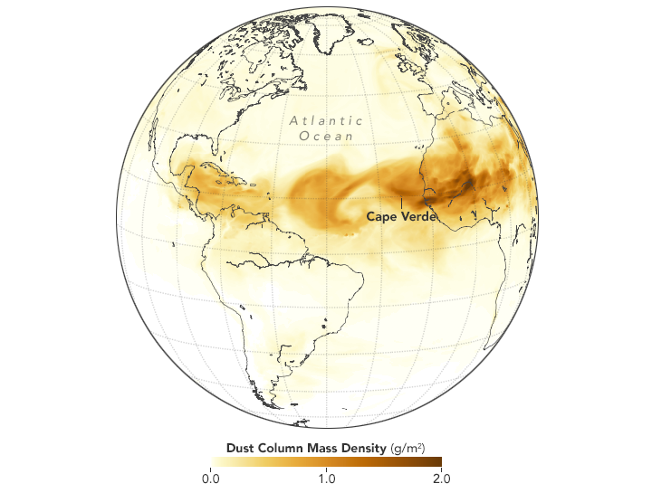
Earlier this month, a cloud of dust rolled into the atmosphere above Texas and the Gulf Coast. It was a remnant of a storm blown over from the Saharan desert. And like the wildfire smoke currently impacting air quality in the Northwest, the dust has created poor breathing conditions for people living in the haze.
[Black holes and the tango have a lot more in common than you might think.]
But, according to a new study, that Saharan dust also brings with it a silver lining—it suppresses the formation of major storms. Bowen Pan, Ph.D. candidate at Texas A&M University, joins John Dankosky to explain why a dusty atmosphere could mean a less severe hurricane season.
Decided to get a few pics of the sunset tonight. Saharan sunset in Texas.The dust storm is still dusting. #duststorm #AfricanDust #Houston #photography #Texas pic.twitter.com/NCXrrUd26r
— Deborah M (@writerDM) July 17, 2018
What a glow!
Amidst an evening drizzle, the sun and saharan dust painted the sky a golden glow yet again tonight #lawx @theadvocatebr pic.twitter.com/74NDBZsF5u
— Hilary Scheinuk (@hscheinukphoto) July 19, 2018

Bowen Pan is a PhD candidate in the Department of Atmospheric Sciences at Texas A&M University in College Station, Texas.
JOHN DANKOSKY: So what do wildfire smoke and dust from the Saharan desert have in common? Well, earlier this month, a cloud of dust came rolling into the atmosphere above Texas and the Gulf Coast. It was a remnant of a dust storm blown over from the Saharan desert. And like the smoky conditions in the west, the dust has impacted air quality and breathing conditions for people living in the haze.
But according to a new study in the Journal of Climate, that Saharan dust also brings with it a silver lining. It suppresses the formation of major storms. In fact, my next guest says an especially dusty atmosphere is a strong indicator of a less severe hurricane season. Bowen Pan is a post-doc research associate in the Department of Atmospheric sciences at Texas A&M University. And Bowen, welcome to Science Friday. Thanks so much for being here.
BOWEN PAN: Thank you so much for inviting me, John.
JOHN DANKOSKY: I’m wondering if you can just start with the most obvious question people will have. How exactly did dust from the Sahara Desert in Africa make it all the way over to the US?
BOWEN PAN: So first, when the dust at the Saharan Desert– when there is a strong surface wind, and when the surface wind is sitting at certain thresholds, the dust can emitted from the surface towards the mid [INAUDIBLE] atomosphere. So it can reach as high as several kilometer high. And then this dust followed the trade wind from the Azores high. So it’s blowing from the West African towards the United States. It’s going to follow the trade wind across the North Atlantic Ocean, and reaching the US. That’s normally how it’d get there.
JOHN DANKOSKY: So that’s how it happens. And is this happening a lot? Is it happening more often?
BOWEN PAN: I think, for this year, it happening more often than before. And then I think the Azores high is much stronger than before. That’s where you have a much stronger trade wind. So that’s why we have this more frequent dust outflow into the Houston region, yes.
JOHN DANKOSKY: So the dust gets blown up into the atmosphere. How long, exactly, does it take it to get here– to, say, Houston?
BOWEN PAN: So normally it’d take about 7 to 10 days to just travel from the West African to Houston region, and it also can take about 13 days just travel around the globe. It can travel really far away.
JOHN DANKOSKY: And since it’s being blown by the winds– I’m not sure. Is it blowing across and then leaving quickly, or is it lingering over one part of a country?
BOWEN PAN: It really depends on the local meteorology condition. So if the wind is not strong enough, so the dust can stay in certain region for a long time. But normally, it travels from across Atlantic Ocean. It can be pretty fast, since the trade wind is pretty strong over there.
JOHN DANKOSKY: OK, so let’s get into how it might suppress storms. I guess I always thought that particles in the air made it more likely clouds would form, and clouds would lead to rain. So why would all this dust in the atmosphere make the storms less likely?
BOWEN PAN: Yeah, I’m glad you brought it up. And actually, dust can have two different impacts on the storms. So the one you were talking about is dust can play a role in cloud formation. So we call it microphasic effect. But here, in my study, I’m looking more of a radiative effect.
So the dust is absorbing and reflecting sunlight, so that’s how it increasing the temperature in the middle atmosphere but decreasing the temperature at the sea surface level. So it stabilizes the atmosphere. That’s why we have more of a suppressed hurricane condition when we have more dust outflow.
JOHN DANKOSKY: So this dust is hanging at a place in the atmosphere. Explain about how far off the Earth’s surface this is traveling.
BOWEN PAN: So normally it’s in about 2 kilometer high above the sea surface. So normally, around the sea surface area, we have relatively colder temperature. And then about that high level, we have a relatively warmer temperature over there, and then it can travel thousands of kilometer, just to reaching the US.
JOHN DANKOSKY: I’m John Dankosky, and this is Science Friday from WNYC Studios. And we’re talking with Bowen Pan, a PhD candidate in the Department of Atmospheric Sciences at Texas A&M University, about how dust from the Sahara might be causing interesting climatic conditions here in the United States. So remind us again how storms work. If we’re talking about a major storm like a hurricane, where does the storm get its energy from?
BOWEN PAN: So normally, the storm form as a cluster of thunderstorm from off from the West African coast. So we call it African easterly waves. So about 40% or more than 50% of the hurricane in the Atlantic Ocean is forming from the cluster of thunderstorms.
So those thunderstorm moved towards a warmer sea surface temperature– so normally warmer than 80 degree Fahrenheit. So they get the energy from the sea surface– so caused by evaporation and latent heat release. That’s when the hurricane really– or the storms really build up vertically and form a hurricane there.
JOHN DANKOSKY: So then the dust does what? Dust acts like a window shade? It keeps down the amount of heat that’s being used as fuel for the storm?
BOWEN PAN: Yes, sort of like that. The dust reflects and absorbs sunlight, so it warm up in the mid-atmosphere, and then cool down the sea surface. So stroking the storm to build up vertically, basically.
JOHN DANKOSKY: Are there some examples where we’ve seen this– times at which there was a lot of dust activity and it coincided with hurricane season?
BOWEN PAN: Yes, I’m glad you bring this up. So for our study, we’re looking at the year of 2005 and 2006. So when we are at the year of 2005, that’s when we have those really catastrophic– Hurricane Katrina at that time. So we have 20 plus hurricanes at that year.
And so for the year of 2006, the National Hurricane Center predicted above-average hurricane season– so relatively active. But in the end, in 2006, we only have about 10 hurricanes at that time. So researchers are wondering what is the cause of it, and then we see that the Saharan dust events is more frequent in the year of 2006, which decreasing the sea surface temperature at that time and then suppressed the hurricane season at the year of 2006.
JOHN DANKOSKY: So 2005 is a terrible hurricane season. We predict another one in 2006, but then there’s a big dust storm. And you’re saying that’s what tamped down the hurricanes in the following year.
BOWEN PAN: Yes.
JOHN DANKOSKY: Well, so with all of this, is the evidence here strong enough that forecasters should start to put this data into their models, where if there’s a lot of dust coming from the Sahara, that might mean, well, we won’t have as bad a hurricanes as we’re expecting?
BOWEN PAN: Yeah. It’s actually a really active research field right now. So the prediction of Saharan dust events is challenging right now. But taking into account the Saharan dust events is definitely going to help us to make a better prediction of the hurricane season in the following year, definitely.
JOHN DANKOSKY: But you say it’s kind of hard to predict the Saharan dust storms. Now, why is that? We’ve got these models that show when hurricanes are forming in the Atlantic and coming toward the United States. Why don’t we know more about the dust events that are happening in the Sahara?
BOWEN PAN: Yeah, so when we are doing the prediction of Saharan dust events, we need more detail of the surface texture. So right now, I think this data is still limited from a certain resolution. So it’s still coarse resolution right now. And then we also need to predict the surface wind correctly, but still a challenging topic in our field. So that’s why the prediction of Saharan dust events is challenging and heated topic right now.
JOHN DANKOSKY: It’s a very interesting topic, as well. Thanks so much for bringing it to us. Bowen Pan is post-doc research associate in the Department of Atmospheric Sciences at Texas A&M University. Thanks for joining us.
BOWEN PAN: Thank you very much.
Copyright © 2018 Science Friday Initiative. All rights reserved. Science Friday transcripts are produced on a tight deadline by 3Play Media. Fidelity to the original aired/published audio or video file might vary, and text might be updated or amended in the future. For the authoritative record of Science Friday’s programming, please visit the original aired/published recording. For terms of use and more information, visit our policies pages at http://www.sciencefriday.com/about/policies/
Katie Feather is a former SciFri producer and the proud mother of two cats, Charleigh and Sadie.