Grade Level
6-12
minutes
1- 2 hrs
subject
Earth Science
Activity Type:
earth science, geology, igneous rock, glacier, virtual field trip
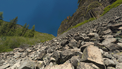
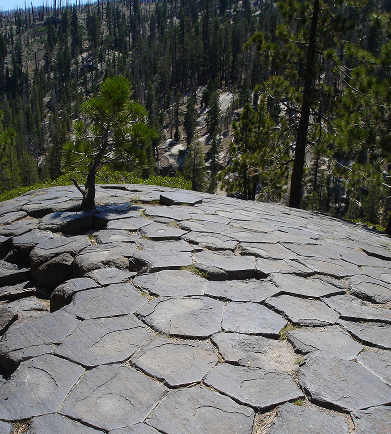
Welcome to the Columns of the Giants!
Just click, hold, and drag to explore the Columns of the Giants in California. Zoom in to take a closer look by using your mouse or the toolbar.
Navigating the tour is simple. Hover over the toolbar with your mouse to show each button’s function. To see a demonstration of how to use the field trip, click here.
What interesting features do you notice about the landscape, and how do they appear similar to those in the photos of Iceland featured in “The Land of Volcanoes, Glaciers, and Mars-Like Deserts”? Why do you think they call this formation Columns of the Giants?
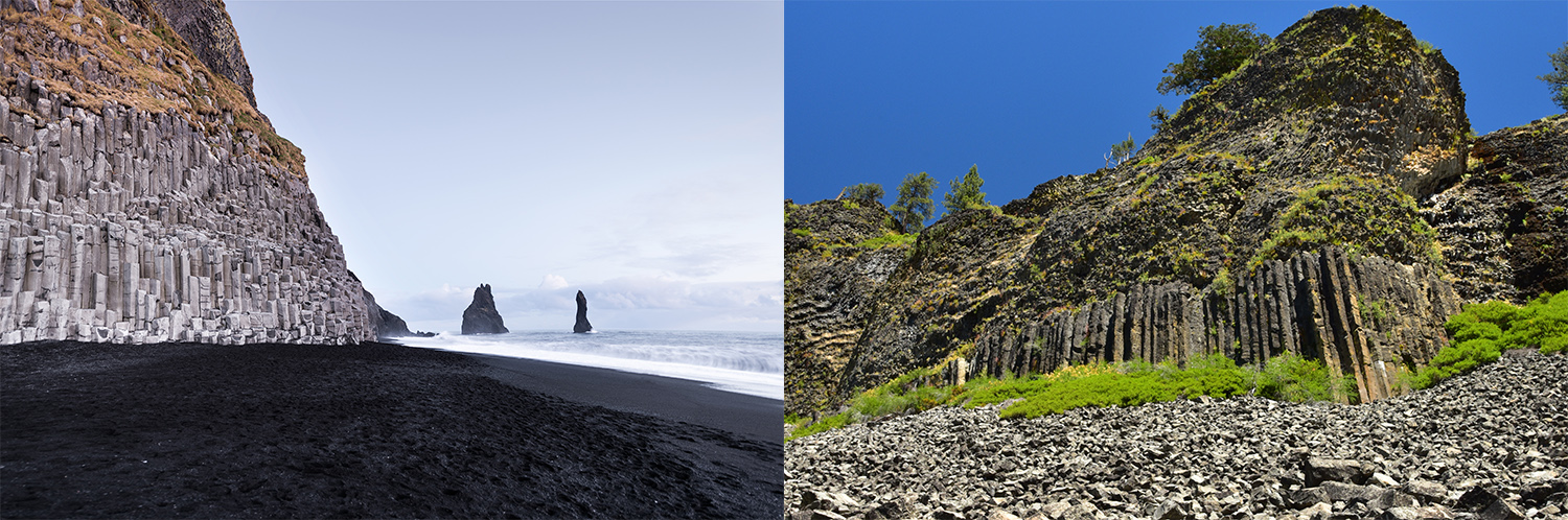
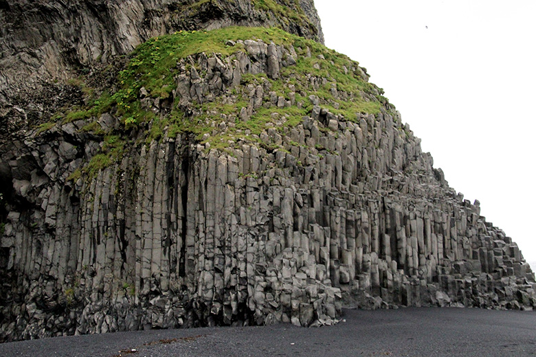
Take a look at the two photos above. The one on the left was taken in Iceland, and the one on the right in California. Both locales have fascinating tectonic underpinnings: Iceland straddles a divergent plate boundary and sits atop a hot spot giving rise to many volcanoes. Much of California’s coast grinds laterally along the San Andreas Fault, which is responsible for the frequent earthquakes that the region is known for.
How can two places more than 4,000 miles apart, and with such different tectonic settings, have such similar landforms? To answer that question, let’s take a virtual field trip to the Columns of the Giants—the geologic formation pictured in the second photo, and located in the central Sierra Nevada Mountains. In this resource, you will learn how to decipher some of the physical processes that shaped the land structure, or “geomorphology,” of parts of California, which will help you better understand how Iceland’s distinct landscape might have also formed.
- Learn about clues that might help you understand how this landscape formed, like evidence of lava flows, rock types, evidence of glaciers, and the growth of lichens.
- Collect evidence from the Columns of the Giants.
- Apply your geology skills to other landscapes.
How can observational evidence from the Columns of the Giants help you figure out what created these rock formations?
Look for Evidence of Lava Flows
Lava flows leave behind many clues that help geologists understand how they flowed out of the volcano, as well as how quickly they cooled. Below are several clues left behind by the flow at the Columns of the Giants.
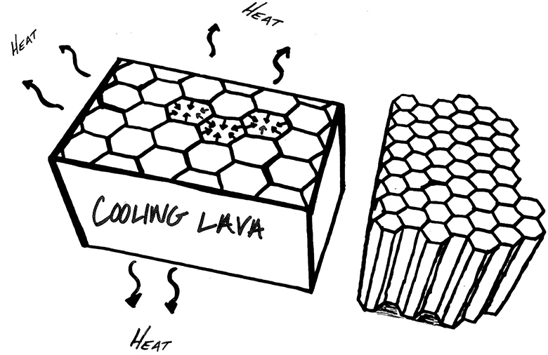
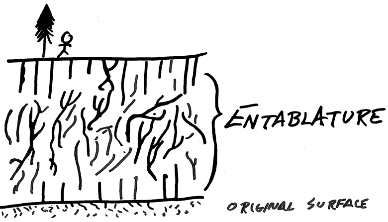
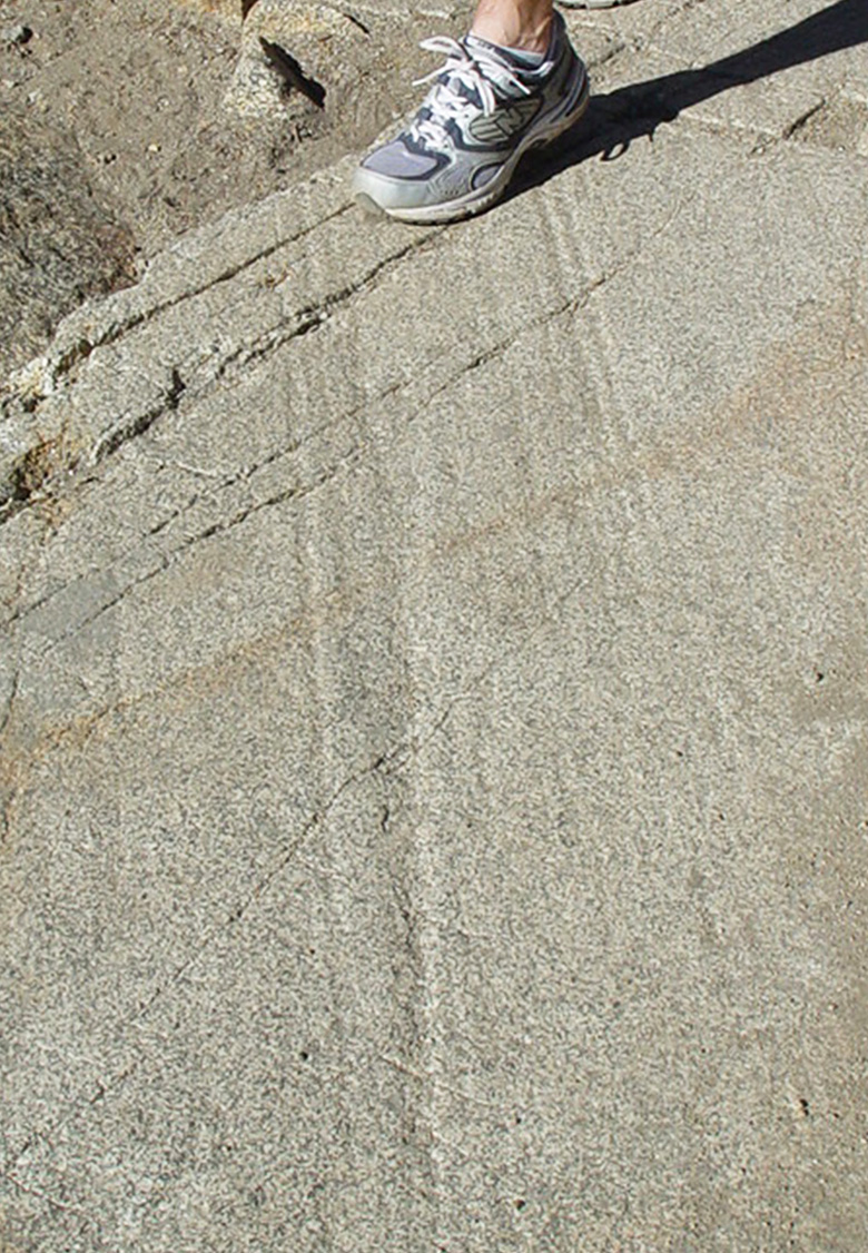
Columnar jointing happens as a result of stagnant pools of lava cooling slowly. As the lava cools and crystalizes into rock, the atoms in the lava become more organized and take up less space than when the lava was a hot liquid. As a result, the solidifying rock shrinks, causing cracks to form in the surface. The cracks radiate outward at 120-degree angles from one another, forming hexagonal shapes that lend the surface a honeycombed appearance. Over a cooling period of several decades, those cracks, called “joints,” also spread down through the solidifying rock, meeting other cracks spreading up from the bottom, and forming column-like shapes.
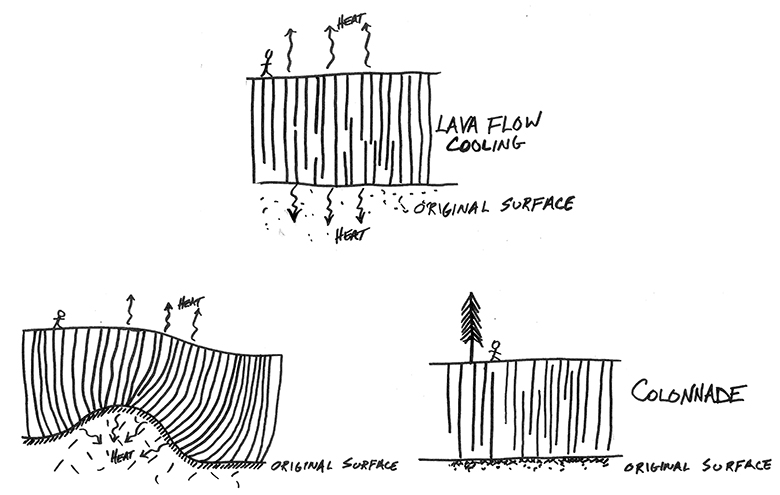
Columns form perpendicularly to the surface that the original pool of lava rested upon. These columns will lean or appear bent if the bottom of the lava pool lies on top of surfaces that are uneven, such as a hill or stream channel.
Examine and Identify Rocks
The Columns of the Giants, as well as the surrounding Sierra Nevada mountains, are part of a family of rocks called igneous rocks.
Igneous rocks form when magma (hot liquid rock) cools and solidifies, either underground or after erupting onto earth’s surface as lava. By examining the crystal size and composition of igneous rocks, you can infer their origins.
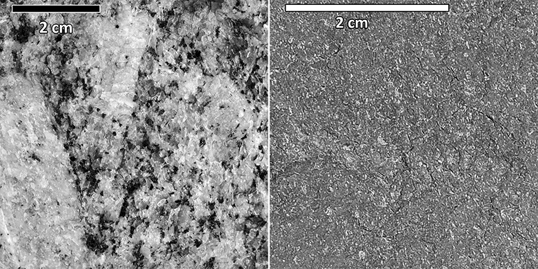
Igneous rocks that contain large interlocking mineral crystals (what geologists call a coarse-grained texture) formed from magma that slowly cooled and solidified miles beneath earth’s surface over a period of millions of years.
Fine-grained igneous rocks (as well as those with a glassy texture) likely formed in a volcanic eruption that occurred above ground and cooled very quickly in a matter of hours, days, months, or years.
You can use this rock identification guide to help you differentiate between rocks encountered at the Columns of the Giants.
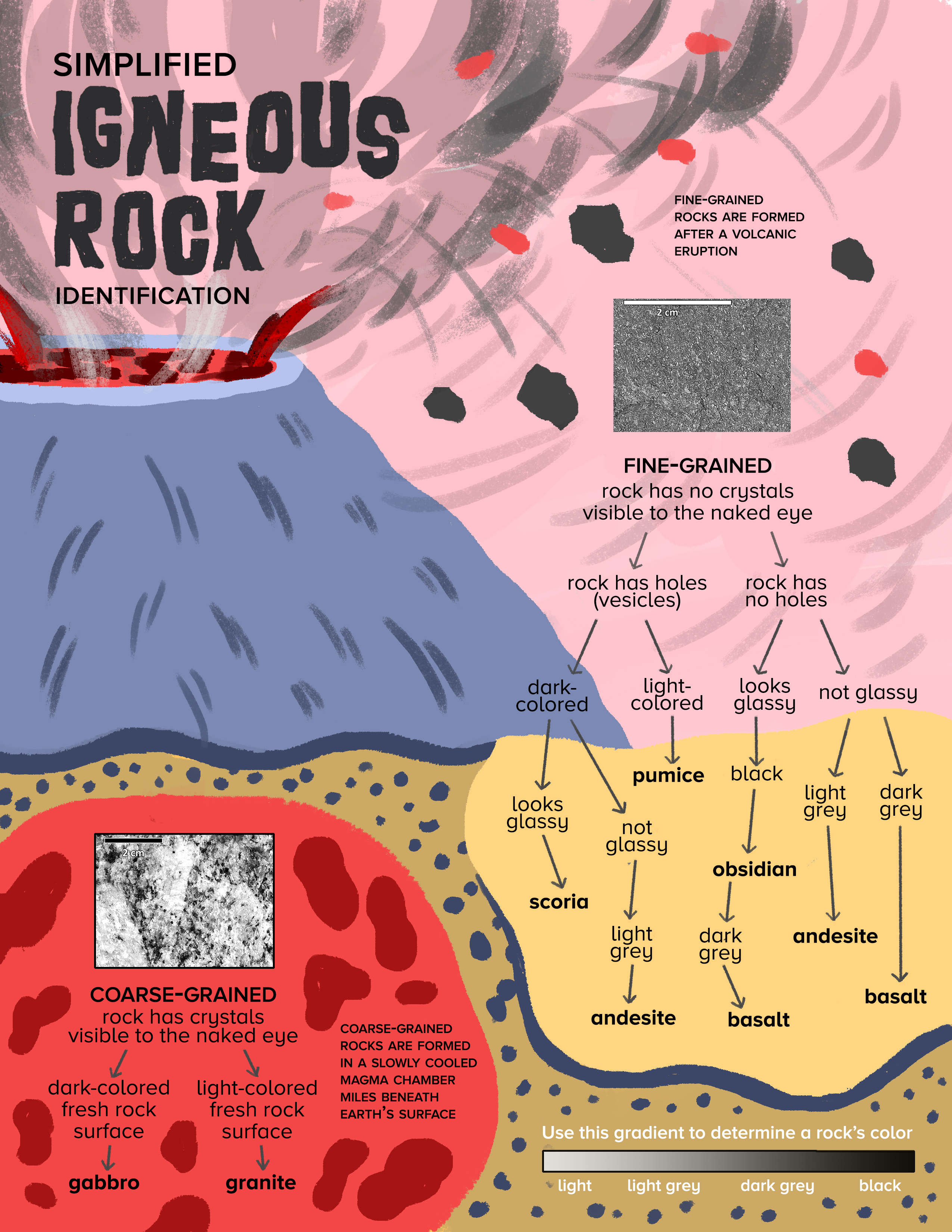
A variety of coarse-grained igneous rocks that cooled slowly underground and fine-grained igneous rocks that cooled rapidly in an eruption occur at the Columns of the Giants. Such a variety begs the questions: How did coarse-grained rocks that formed miles beneath the surface become exposed? What happened to the miles of rock that used to bury these rocks? How did fine-grained, fast-cooling rock end up next to coarse-grained, slow-cooling rock?
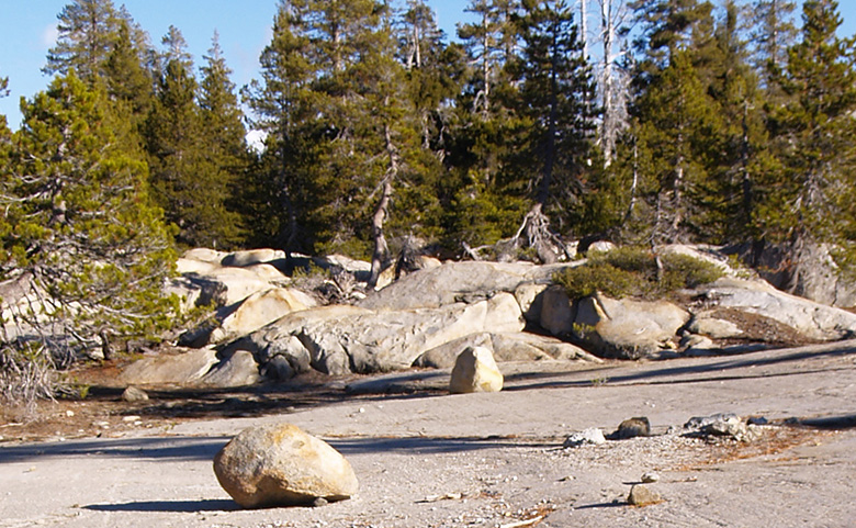
Look for Evidence of Glaciers
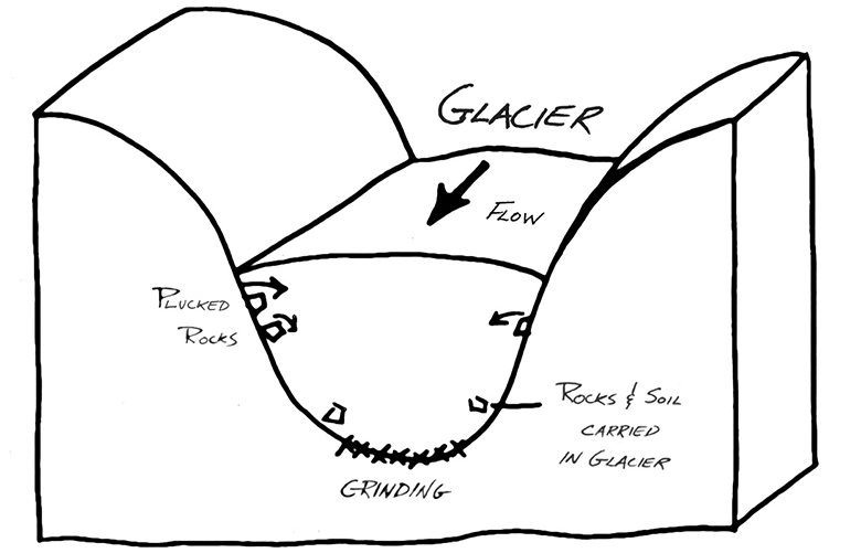
Few natural phenomena on earth have the power to shape landscapes as dramatically as glaciers. Glaciers that are several thousand feet thick with rocks and sand trapped at their base easily exert enough force to scrape, grind, and polish the rocks over which they flow. They can even carve giant valleys and scrape away all the soil from the land over which they flow. Modern glaciers’ rapid retreat due to anthropogenic climate change allows scientists to observe evidence of glaciers on the freshly exposed rocks.
Glacial Striations – Parallel scrape marks on rocks created as a glacier with rocks and dirt stuck in its base grates the ground over which it flows.
Glacial Erratics –Rocks that were trapped inside and transported by a glacier. When glaciers melt, these rocks are left behind, typically on ground composed of a different type of rock.
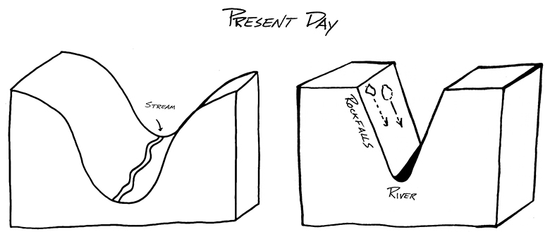
U-Shaped Valley – Glaciers flowing down previously existing V-shaped river valleys will pluck and grind rocks, widening the valley. In contrast, valleys carved by a river make a V-shaped canyon (compare the illustrations below).
Absence of soil – As glaciers scour an area, they strip the surface of all soil.
![Lichen has grown on this chunk of granite. By Churnice (Own work) [CC BY-SA 3.0 (http://creativecommons.org/licenses/by-sa/3.0)], via Wikimedia Commons](http://www.sciencefriday.com/wp-content/uploads/2016/12/11-LichenGranite.jpg)
Estimate the Passing of Time With Lichens
The scientific field lichenometry uses the growth rate of lichens to determine the age of rock falls and exposed rocks.The basic idea of lichenometry is this: the more lichen there is on a rock, the longer the rock has been resting in that location, undisturbed. Since lichens grow at a rate of 2-5 mm per year, it takes a long time for them to become established on rocks. Thus, rocks with lichens on them have probably been lying in the same place for a long time. Depending on environmental conditions, lichenologists can make fairly accurate age determinations of how long a rock surface has been exposed based on the extent of lichen cover.
For printable versions of the Geological Evidence Guide and Rock Identification Chart see the Educator Toolbox below!
Explore and Collect Evidence: Columns of the Giants, Stanislaus National Forest
This version of the field trip contains additional clues, data, and specimens to help you piece together the geological history of the Columns of the Giants. The field study site consists of six interactive 360° photosphere scenes, called “stops,” at the Columns of the Giants in Stanislaus National Forest in California. Check out the map below to see the positions of the “stops.”
In order to collect evidence and construct a hypothesis about the formation of this fascinating region, you will move through the photospheres by reading descriptions and answering question prompts, making observations, and even “picking up” and examining detailed 3D models of rocks that are found there—all while taking notes in a field journal.
As you go, you’ll learn how to find evidence of lava flows, identify rock types, hunt for glacier clues, and even observe lichens to infer how the landscape was formed.
- Tablet or computer with Internet access
- Pencils and erasers
- A field notebook, preferably one with graph paper. To get started check out Field Notebook Basics.
- Rock Identification Chart
- Geologic Evidence Guide
- Printable Guided Stop Questions
How to find information in this virtual tour:
The light blue number tags denote areas of interest, stop questions, or contain additional information. The light blue circles containing a cube provide links to 3D models or rock specimens. Clock icons indicate areas with known radiometric age dates. (Radiometric dating measures the ratio of small amounts of naturally occurring radioactive isotopes trapped within a rock after it crystalized from magma to determine how long ago the rock was created.) The red map pins denote the location of another viewpoint, or “stop,” on the tour.
- Explore each stop using the 360° photosphere scenes, clicking each of the tags and 3D models to make observations and sketches of details you find geologically interesting in your field notebook. (Be sure to pick up and observe 3D models of rocks by clicking on the cube icon when it appears at stops #1 and #5.)
- Make observations and add sketches to your field notebook as you go, answering questions at each tag about features of interest, using this Geologic Evidence Guide to help you.
- Use Evidence to Construct a Hypothesis
Based on the evidence you’ve collected and interpreted during your field study, create a timeline of geologic events that you hypothesize helped shape the Columns of the Giants we see today. Start your timeline at 150,000 years ago and work your way forward, being as detailed as possible. Use the precise age listed in the “clocks” as a starting point. Then do your best to order the rest of the events based on which came first, second, third and so on. Geologists call this relative dating, and there is lots of room for different interpretations of the same evidence!
Apply your new geo-sleuthing skills!
Apply your new geo-sleuthing skills to hypothesize how various landscapes on earth and across the solar system originated. Below are a series of photos from Iceland and other locations that exhibit similar traits to what you observed in your field study. Do your best to analyze each photo and hypothesize about how each landscape was formed. Try to answer the following questions as you make your comparisons:
- What type of rock is seen in the photo? Is it igneous?
- What is the rock’s specific name? How do you know?
- How did the rock originally form? How do you know?
- What has happened since the rock first formed to make it look the way it does today? How can you tell?
Mt. Reynisfjall, Iceland
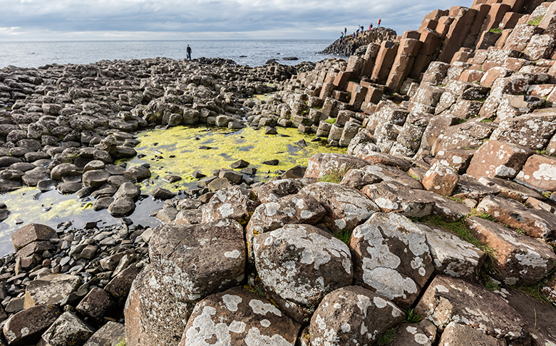
Giants Causeway, Ireland
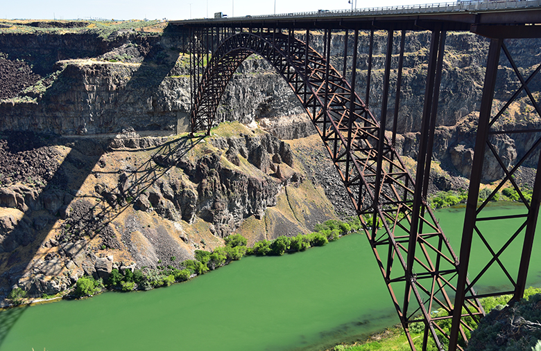
Twin Falls, Idaho
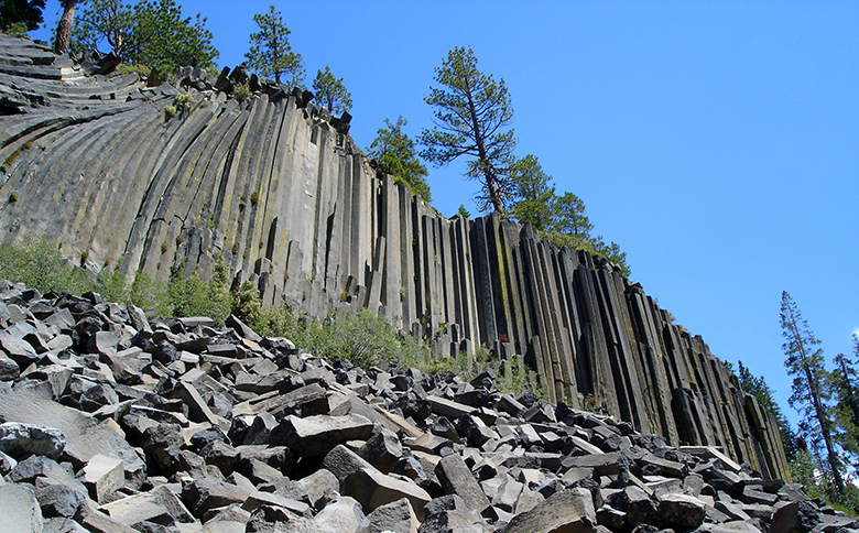
Devils Post Pile National Monument, CA
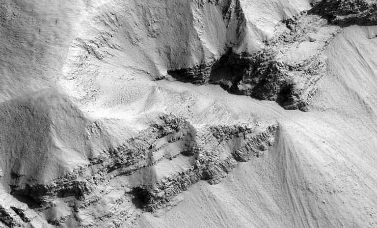
Marte Vallis, Mars
Share Your Field Observations!
Take a pic and share your fieldwork sketches on social media by tweeting them @phaneritic and @scifri!
Further Experimentation
- Create your own jointed columns using cornstarch and water, similar to the testing in this paper.
- Explore more about polygonal cracking in natural materials, like mud or lava flows through the activities in “Cracking the Clues” via Earthlearningidea.com.
References
- Bentley, Callan. “A Virtual Field Trip to the Giant’s Causeway, Northern Ireland – Mountain Beltway.” Mountain Beltway Site Wide Activity RSS. AGU, 25 June 2016. Web. 08 Aug. 2016.
- Glazner, Allen F., and Greg M. Stock. Geology Underfoot in Yosemite National Park. Missoula, MT: Mountain Pub., 2010. Print.
- Huber, N. King. “Preliminary Map of the Dardanelles Cone Quadrangle, Central Sierra Nevada, California.” Sierra Nevada Batholith Geologic Map Mosaic. USGS, n.d. Web.
- Hughes, Noah, and Garry Hayes. Geological Excursions in the Sonora Pass Region of the Sierra Nevada. First ed. San Diego: Sunbelt Publications, 2012. Print.
- Long, P. E., and B. J. Wood (1986), Structures, textures and cooling histories of Columbia River basalt flows, Geol. Soc. Am. Bull., 97, 1144–1155.
- Kilauea Iki’s lava lake has finally crystallized. (2003, January 9). Retrieved December 04, 2016, from http://hvo.wr.usgs.gov/volcanowatch/archive/2003/03_01_09.html
Conclusion
The geologic stories revealed by just a few observations at The Columns of the Giants are quite amazing. It is also quite amazing that such similar geological stories have played out time and time again in such varied settings. You now have one piece of evidence to argue that both Iceland and California have at least one geomorphologic commonality. If you’d like to see large columns that are near you, consult this list. Happy hunting!
Thanks
Creating this virtual trip was a labor of love for the author. He greatly appreciates the support his wife and three-year-old son during the 200+ hours spent developing and revising the project during their summer vacation. He’d also like to thank Modesto Junior College geology professors Garry Hayes and Noah Hughes for being his field trip mentors and providing the original spark of interest in Columns of the Giants.
Educator's Toolbox
Meet the Writer
About Ryan Hollister
@phaneriticRyan J. Hollister is a veteran geoscience and AP environmental science teacher at Turlock High School in Turlock, California. Through a signature blend of enthusiasm and expertise, he fosters an appreciation in his students for the physical processes that have shaped the region they call home: California’s Great Central Valley. Ryan’s ultimate goal is to help shape a citizenry that will solve the air and water quality problems that plague the San Joaquin Valley.