Embracing The Salt And Adapting To Sea Level Rise
33:58 minutes
 This story is part of Degrees Of Change, a series that explores the problem of climate change and how we as a planet are adapting to it. Tell us how you or your community are responding to climate change here.
As the frequency of tropical storms and droughts increase and sea levels rise with climate change, forested wetlands along the Atlantic coast are slowly filling with dead and dying trees. The accelerating spread of these “ghost forests” over the past decade has ecologists alarmed and eager to understand how they are formed and what effect they will have regionally and globally.
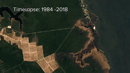
One interdisciplinary group of researchers from North Carolina State University and Duke University are examining the causes and effects of repeated saltwater exposure to the coastal wetlands of North Carolina. Using soil and sediment sampling, remote hydrological monitoring, vegetation plotting, as well as spatial maps, the research team is determining the tipping point for when a struggling forest will become a ghost forest. According to ecologist Emily Bernhardt, their preliminary findings suggest that climate change is not the only culprit in the region.
Agricultural irrigation and wastewater ditches that criss-cross much of the Albemarle-Pamlico Peninsula facilitate the flow of saltwater intrusion deep into the landscape, wreaking ecological and economic havoc. Working with Brian Boutin, director of the Nature Conservancy’s Albemarle-Pamlico Program, Dr. Bernhardt and colleagues hope to provide valuable scientific insights to local farmers, wetlands managers, and regional decision-makers to plan for the further intrusions and hopefully mitigate the effects.
In Science Friday’s latest Macroscope video, the scientists involved explain how they’re assessing and and dealing with these ghost forests.
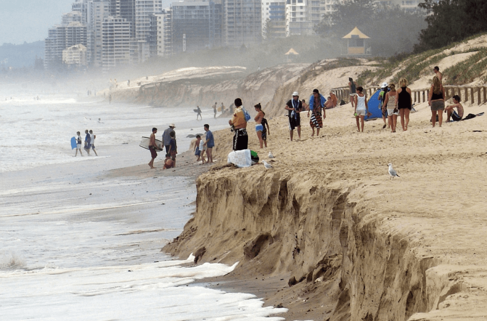
Meanwhile, less than 100 miles up the coast from the Albemarle-Pamlico peninsula, the cities of Hampton Roads, Virginia along the Chesapeake Bay are facing some of the worst flooding due to sea level rise in the country. In Norfolk, home of the United States Navy, tides have increased as much as eight inches since the 1970s, and roads that lead from the community directly to naval installations are particularly vulnerable to flooding.
But in the last 10 years, Hampton Roads has begun to adapt. “When we first started having these discussions, there was a lot of concern about, should we be having discussions like this in public. What would be the potential impacts on economic development or on the population growth here?” said Ben McFarlane, senior regional planner with the Hampton Roads Planning District Commission. “Now it’s recognized and people know it’s happening. I think the strategy has changed to being more of a ‘Let’s stop talking about how bad it is and how bad it’s going to get. And let’s start talking about solutions.’”
The Planning District Commission supports the use of living shorelines and ordinance changes that discourage developing in flood prone areas. Norfolk has even been named one of the Rockefeller Foundation’s 100 Resilient Cities in part for its efforts promoting coastal resiliency in the face of sea level rise.
McFarlane joins Ira and Virginia Institute of Marine Science researcher Derek Loftis, whose research focuses on building hydrodynamic flood forecast models and prediction via remote sensing to enhance future resilience, to discuss how Hampton Roads is embracing the sea and adapting to climate change.
Want to help keep track of sea level rise in your community? Participate in citizen science projects to keep track of King Tides. The Virginia Institute of Marine Science, which developed a state-wide street-level flood forecast model, trains citizen scientists how to use an app called Sea Level Rise that allows coastal Virginians to take pictures and log GPS breadcrumbs of King Tides. The next King Tide will occur on the morning of Sunday, October 27, 2019. As you walk along the edge of the high water mark, the app will drop GPS data points every few steps, giving researchers useful data about how this year’s King Tide compares to previous ones. Get involved with the project by signing up here and download their app for iOS or Android.
Don’t live in Virginia? You can also download MyCoast for iOS or Android. MyCoast allows you to submit King Tide reports, as well as photos of abandoned boats and large marine debris along the coastal U.S. The organization, which has partnered with NOAA and multiple state agencies, will submit your data to local coastal decision makers and emergency managers to make better choices.
Emily Bernhardt is a professor of Ecology in the Department of Biology at Duke University in Durham, North Carolina.
Brian Boutin is Director of the Albemarle-Pamlico Sounds Program at The Nature Conservancy in North Carolina, based in Kill Devil Hills, North Carolina.
Kristina Dahl is a senior climate scientist with the Union of Concerned Scientists in San Francisco, California.
John Derek Loftis is an assistant research scientist at the Virginia Institute of Marine Science in Gloucester Point, Virginia.
Benjamin McFarlane is a senior regional planner with the Hampton Roads Planning District Commission in Chesapeake, Virginia.
Katie Feather is a former SciFri producer and the proud mother of two cats, Charleigh and Sadie.
Luke Groskin is Science Friday’s video producer. He’s on a mission to make you love spiders and other odd creatures.
Dee Peterschmidt is Science Friday’s audio production manager, hosted the podcast Universe of Art, and composes music for Science Friday’s podcasts. Their D&D character is a clumsy bard named Chip Chap Chopman.
Ira Flatow is the founder and host of Science Friday. His green thumb has revived many an office plant at death’s door.