Looking Ahead To Hurricane Season
12:00 minutes
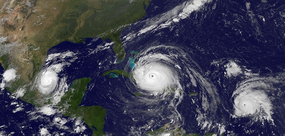
June 1 marks the start of the official “hurricane season” in the Atlantic, the time when powerful storms are most likely to spin their way out of the tropics. Each year, teams of forecasters try to anticipate the number and severity of storms to come. Some try to run climate models that simulate atmospheric behavior over multi-month timeframes, while other teams rely on statistics and comparisons with historic data for their estimates of the upcoming storm season.
[Haven’t you always wanted to visit the Smallest Mollusk Museum?]
Michael Bell, co-author of Colorado State University’s seasonal hurricane forecast, says that after looking at factors including Atlantic sea surface temperatures, sea level pressures, vertical wind shear levels, and El Niño, their team is predicting 13 additional named storms during the 2018 Atlantic hurricane season (in addition to Alberto, which formed before the Atlantic hurricane season began). Of those storms, the forecast calls for six to become hurricanes and two to reach major hurricane strength. That’s in line with a separate forecast from NOAA’s Climate Prediction Center estimating between 10-16 named storms and 5-9 hurricanes.
Bell joins Ira to talk about the challenges of long-term weather prediction, the interplay between climate and weather, and how the water temperatures off the coast of Africa tie into the chances of storms striking Florida.
Michael M. Bell is co-author of the Colorado State University seasonal hurricane forecast, and an associate professor in the Department of Atmospheric Science at Colorado State University in Fort Collins, Colorado.
IRA FLATOW: This is Science Friday. I’m Ira Flatow. Later in the hour, we’ll dive into the sea for oceans month and talk about how drones can help map the deepest depths. But first. Today marks the official start of the Atlantic hurricane season, that time when forecasters keep a close eye on storms swirling their way out of the tropics.
And this season is already a bit different. Tropical Storm Alberto made his appearance early before the start of the season and as a subtropical cyclone made its way through the upper Midwest, drenching the Great Lakes states. Tropical weather in the Great Lakes? Is that a sign of things to come? Is that the new normal?
Michael Bell, associate professor in the Department of Atmospheric Science at Colorado State University in Fort Collins, Colorado. He is co-author of the Colorado State University seasonal hurricane forecast, and he joins us now. Welcome to Science Friday.
DR. MICHAEL BELL: Thank you for having me on the program.
IRA FLATOW: First, let’s talk about Alberto. How unusual is this?
DR. MICHAEL BELL: Well we typically see some storms that form in the Gulf of Mexico around June. Even though June 1st is the official start of the hurricane season, it’s not that unusual to have something just a little bit before that of this type of system.
So in this case Alberto, as you just mentioned in the intro, is a subtropical storm, which means that it was a bit of a hybrid between what we typically think of as tropical storm, which has fuel coming from the warm ocean surface, and winter storms, which gets their energy from temperature gradient and atmosphere. So this sort of hybrid storm is something that we kind of expect to see every once in a while in the early part of the season.
IRA FLATOW: But so far north that hits the Great Lakes too?
DR. MICHAEL BELL: Yeah. So that is a bit unusual when we were looking at the radar imagery as it tracked across the Midwest. If you took the map off of it, you wouldn’t necessarily expect it to see such a well-formed storm that far north.
Brian McNulty at the Washington Post recently just published an article, though. Turns out there’s been actually 11 storms that have passed over Lake Huron over the years, although Alberto was the earliest on record to go that far north. So I think, in part, it’s due to that hybrid nature of the storm. But it’s certainly something interesting to go back and look at and see how it’s made able to survive for so long and make its way so far north.
IRA FLATOW: All right. Let’s talk about your yearly forecast. This year’s new forecast you released yesterday. What are you predicting for the months ahead?
DR. MICHAEL BELL: Well, we’re predicting 14 named storms. So that’s tropical storm strength or higher. Of those, we are forecasting six to make hurricane strength and two to make major hurricane strength, which is category 3 or higher. So those numbers are actually down a little bit from our extended range forecast we put out in April, and they’re pretty close to the long term averages.
So on average, we would expect about 12 named storms in a season, close to six at hurricanes, and two major hurricanes as well. So we’re forecasting a pretty average season moving forward, and that 14 named storms does include Alberto. So we’re expecting about 13 more after this point.
IRA FLATOW: Well, why did you downgrade the number that you said earlier? You predicted a little bit more, but now a little less.
DR. MICHAEL BELL: Yeah, I think the biggest factor is really the changing ocean temperatures off the coast of Africa. So for this forecast, we utilize four predictors in a statistical model, two of which are related to the El Niño Southern Oscillation.
So related to ocean temperatures off the coast of Peru and the equatorial Pacific, and the upper level winds in that region. And then the other two predictors are related to the conditions near Africa. So we look at the sea level pressure in the North Atlantic, and the ocean temperatures off the coast of Africa.
And in the Atlantic right now, the high pressure system that’s parked over the Atlantic, which is a feature that we see every year, is a bit stronger than normal and that it’s increasing the trade winds and actually cooling off the ocean temperatures off Africa. And so since a large part of a hurricane activity occurs due to each of the waves in these Cape Verdean storms, we call them, coming off of Africa in the main part of the summer as we get into July and August and September.
That cooler water we think will inhibit some of the activity. That’s offset, to some extent, by the El Niño conditions. We’re expecting potentially neutral to slightly weak El Niño conditions, whereas last year we had La Niña. And with the La Niña conditions, we saw enhanced activity in the Atlantic.
IRA FLATOW: The difference being? Tell us the difference between the two and how they affect hurricanes.
DR. MICHAEL BELL: Yes. So with the El Niño conditions, the ocean temperatures there affect the large scale vertical wind shear. So hurricanes draw their energy from the warm ocean. So if the ocean in the Atlantic is warmer, that would lead to more intense activity. When the ocean temperatures are warmer in the eastern Pacific, that actually changes the vertical wind shear patterns in the Atlantic.
And if we have more wind shear, that tends to rip the storms apart. So last year, we saw La Niña type conditions which led to some reduced vertical wind shear and a very active season. We’re transitioning out of that La Niña pattern towards an El Niño, but at least right now, the models aren’t suggesting a really strong El Niño will set up. So that’s part of the reason we’re forecasting a near average season.
IRA FLATOW: Are there any symptoms that you can see of climate change affecting the duration or the beginning of hurricanes in the season?
DR. MICHAEL BELL: Yeah, so yeah. That’s a very interesting question. We’ve had, actually, a lot of good email discussions about this. And I think there is some suggestion that the storms are getting earlier. But part of the challenge there is our record of activity over the ocean is actually quite short.
So we can only go back to basically around 1980, at the start of the satellite era, where we have very good records of how many storms and the intensity of those storms. As we go back before that time, most of our records actually come from ship reports. And as you can expect, those tend to underestimate the number of storms since the ships try to avoid the strongest winds.
So it’s difficult to say statistically that that is occurring, and there certainly is an active area of research to look at that. One thing we do know is that there is not a lot of correlation between the number of storms that form in the early part of the season and the total activity, since those tend to be different locations of genesis for the storms.
So as I mentioned before, the storms that form in the early part of the season tend to do so in the Gulf of Mexico where the waters are warmer at the beginning of the season, and then they tend to form more off of Africa later in the season. So there’s not a particularly strong relationship between the number at the beginning and the total activity.
IRA FLATOW: Oh, there isn’t. You’re saying, don’t pay attention. Don’t look behind the curtain, basically.
DR. MICHAEL BELL: That’s right. Well, you know, the conditions definitely change as we get closer, and we really see the peak of the activity occur in August and September. And then for example, last year, we actually had a very near average start to the season even into July and August.
But then September was just a really incredible month that set a tremendous number of records due to very warm ocean temperatures in the Atlantic last year and very low with vertical wind shear, which led to some of those really tragic storms of Harvey, Irma, and Maria. So we hope we won’t see those type of conditions repeat this year.
IRA FLATOW: If we have such variability toward the end of the season, what really great, and I hate to put it this way, what’s the use of the forecast?
DR. MICHAEL BELL: Right. Well, I think there’s a couple of different things. One is we can do better in general than just predicting the average number of storms. So you can make a reasonable forecast just by picking the average every year. And this year, of course, we actually are forecasting the average. But of course, not every year we do that. We go above and below. And so I think there’s some value in that.
But also, it’s also about how do we better understand the hurricanes and what are the large scale conditions that promote those? So those same large scale conditions in the atmosphere and the ocean that produce hurricanes are the ones that cause them to intensify and weaken.
And so I think a big part of this, in terms of the science, is what are these factors? How are all these different very complex atmospheric and oceanic factors working together to produce hurricanes? And so that that helps improve our science.
Also, making these predictions early on, I think it gets people ready for the hurricane season. We always say, it only takes just one. So even though we may predict an average or below average season some years, that shouldn’t change anyone’s preparation. We should always prepare well in advance of the potential hurricanes.
IRA FLATOW: Yeah, as you say, people won’t remember all the other predictions if there is one big one.
DR. MICHAEL BELL: That’s right.
IRA FLATOW: That affects everyone. I mean, Puerto Rico’s still trying to–
DR. MICHAEL BELL: Yes, Puerto Rico is exactly a real good example. And in some years, we may have really low activity, like 1992, but we had Hurricane Andrew. So, you know, even just one storm can cause a lot of damage.
IRA FLATOW: Do you rely on, you know, looking at old, I’m going to say what the meteorologists on TV say, the spaghetti maps? All the different forecasts by different predictors? And you look back in your records and say, oh, that looks like this one, you know?
DR. MICHAEL BELL: Yeah, actually. So for the seasonal forecasts, we do something we call analog predictors where we actually do go look at all the seasons, and we look at the atmospheric conditions that were the same at the same time of year and then look at what happened in those seasons.
The spaghetti diagrams, those are typically for individual storms. And so one of the things we can’t do is make predictions about individual storms this far in advance. So in a way, we look at it sort of from a big picture standpoint of how many storms and how strong they might be on average, but we can’t say with any certainty where any specific storm will go.
Once we get into that about the two week time frame, then the models start to show some skill in being able to predict individual storms. And that’s where those spaghetti models come in and the uncertainty of the individual storms.
IRA FLATOW: There’s so many people involved there. There are builders and forecasters and climate modelers and all these people. Do they ever– do they talk to each other?
DR. MICHAEL BELL: Yeah, actually. I think we’re making a lot of progress in that area, and that’s something that we really want to do more of as a community. You know, my group in atmospheric science, we’re working hard on trying to solve problems related to rapid intensification, heavy rainfall.
It’s a real problem, and trying to understand that as we saw with Alberto, that was one of the main impacts. But we can make the best forecast possible, but if it’s not communicated properly to the public or to the emergency managers or the building codes aren’t up to code, there’s a lot of different factors that go into what makes the hurricane season damaging.
So I think moving forward, we certainly want to do more of that and try and really integrate. And I’m already talking to a lot of people in the engineering department at our university about electrical grids, water systems, and other ways we can all work together to improve hurricane resiliency.
IRA FLATOW: Well, I don’t know what to wish a hurricane forecaster, so I’ll just say, have a healthy hurricane– a forecasting season.
DR. MICHAEL BELL: OK, thank you. And we’ll hope that they all stay away from land this year.
IRA FLATOW: Keep them far, far away, yes. Michael Bell, associate professor in the Department of Atmospheric Science at the Colorado State University in Fort Collins and co-author of Colorado State University seasonal hurricane forecast.
Copyright © 2018 Science Friday Initiative. All rights reserved. Science Friday transcripts are produced on a tight deadline by 3Play Media. Fidelity to the original aired/published audio or video file might vary, and text might be updated or amended in the future. For the authoritative record of Science Friday’s programming, please visit the original aired/published recording. For terms of use and more information, visit our policies pages at http://www.sciencefriday.com/about/policies/
As Science Friday’s director and senior producer, Charles Bergquist channels the chaos of a live production studio into something sounding like a radio program. Favorite topics include planetary sciences, chemistry, materials, and shiny things with blinking lights.