The Science Behind Kilauea’s 30-Year Eruption
16:18 minutes
Hawaii’s Kilauea volcano—located on the Big Island—has been continuously erupting for the past 30 years. But on May 3, magma began spewing through fissures in the Puna district, forcing nearly 2,000 residents to flee. Reporter Ku`uwehi Hiraishi of Hawaii Public Radio spoke to residents in the area of these 15 fissures and describes what type of evacuation efforts have been happening on the ground.
The current eruption of Kilauea does not follow the typical pattern of the last 30 years. Volcanologist Michael Poland of the USGS explains how the flow of magma from this volcano works, how the current eruption differs from the norm, and how scientists are working to forecast future volcanic activity.
Credit: USGS

Ku`uwehi Hiraishi is a reporter for Hawaii Public Radio in Honolulu, Hawaii.
Michael Poland is Deputy Scientist-in-Charge at the Yellowstone Volcano Observatory, part of the USGS Volcano Hazards Program in Vancouver, Washington.
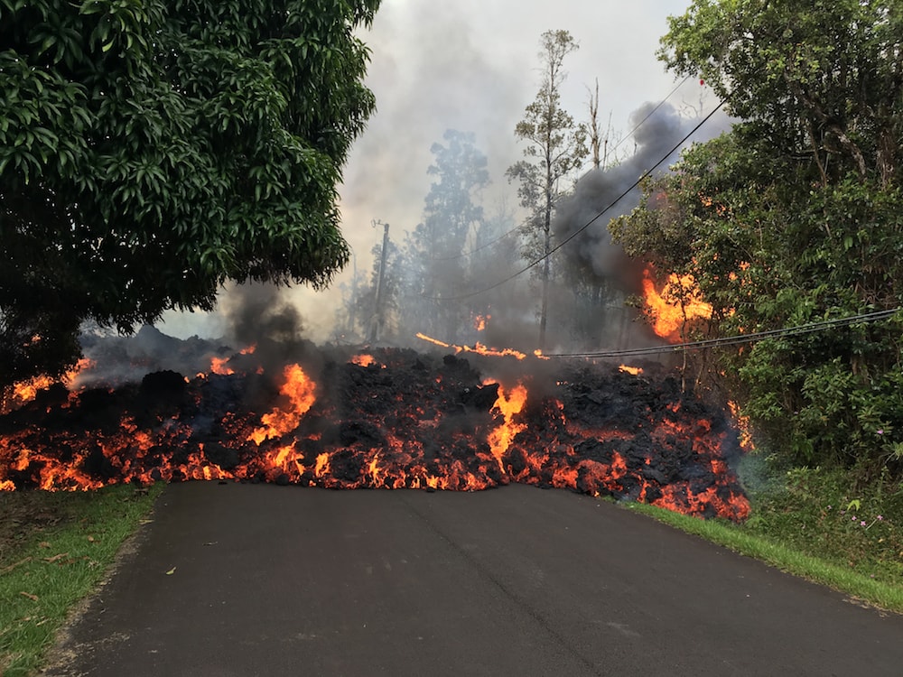
IRA FLATOW: This is Science Friday. Hi, I’m Ira Flatow. On May 3rd, the Kilauea volcano, on Hawaii’s Big Island, began spewing lava from 15 different fissures. The volcano has been continuously erupting for the past 30 years, but this latest event has forced nearly 2,000 residents to flee. Ku’uwehi Hiraishi is a reporter for Hawaii Public Radio in Honolulu, has been on the ground, talking to residents, and joins us with the latest update. Welcome to Science Friday, Ku-uwehi.
KU’UWEHI HIRAISHI: Aloha, Ira.
IRA FLATOW: Aloha. So tell us. The last count is that there are now, what, 15 fissures that have opened up? You’ve seen these fissures. What’s it like on the ground around these fissures and the lava flows?
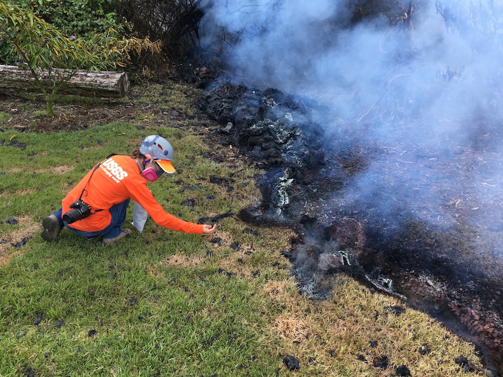
KU’UWEHI HIRAISHI: I did get to witness one right up close. It’s about 150 feet long crack– foot long crack– in the Earth. And at that time, there was no lava. It was safe enough for us to get close to it, but it was still spewing high levels of sulphur dioxide. So at any time, we were informed, that if the National Guard escort with us said to run, we would have to run out of there.
So it was amazing, because it’s laid on the estates where these fissures, this series of fissures, has popped up is in a lush, green rain forest. And so walking, approaching the fissure, it’s cool. You hear birds. You can smell the vegetation. And when you get in about 50– within 50 feet of the fissure, you just feel the heat emitting from it, and you can start stepping on shards of lava-like glass. It’s a site.
IRA FLATOW: Does it feel like you’re on the moon or some other place once you get close by?
KU’UWEHI HIRAISHI: It did. It really did. It felt that– I guess there were still charred, smoking– smoke rising from the charred vegetation around this house, which was spared. So the house, this fissure actually opened up right across Leilani Avenue, right across the road and in front of this gentleman’s house, but spared the house. So it was an unreal scene.
IRA FLATOW: Is there any pattern, discernible pattern, to these fissures?
KU’UWEHI HIRAISHI: So along– these are all happening along the East Rift Zone for Kilauea volcano. And USGS vulcanologists has seen sort of a trend of them being in this one particular line. So if you’re able to look at any aerial views of the fissure or the series of fissures, it’s about 2.5 mile long, or almost three miles, of fissures. They’re all in this one line. So they are continuing to look along that particular line for any future fissures. But they continue to tell us that they are– USGS scientists never predict which way it will go, up or down.
IRA FLATOW: I understand it. And how close is this to Volcanoes National Park?
KU’UWEHI HIRAISHI: Right, so Volcanoes National Park is about 25 miles upland from Leilani Estates. So this is sort of in the southern part of the volcano.
IRA FLATOW: And the state of the relief efforts on the ground, has the governor declared a state of emergency?
KU’UWEHI HIRAISHI: Governor David Ige has declared a state of emergency. So that helps mobilize a lot of the support. He put in a request for FEMA funds. And I know that we just received our federal funds for the disaster over on the other side of the chain of our islands, on Kawaii, with massive flooding just this week. So that took three weeks. We anticipate any word from President Trump to come in another three weeks. So this is going to take some time.
IRA FLATOW: You talked to residents from Puna and Leilani Estates, and we have a clip from [? Kaone Kalave, ?] who came to volunteer.
[? KAONE KALAVE: ?] My family went through the same dilemma in 1960, at the Kapoho village eruption. You know the stories that my kupuna and my parents shared with us about– you know, they had to move out of Kapoho because of the eruption. You know, we need to accept that we’re just here temporarily. Pele is here permanently.
IRA FLATOW: [? Kaone ?] [? Kalave. ?] For Hawaiians, is this sort of an– he expressed sort of an acceptance of– this is part of life here.
KU’UWEHI HIRAISHI: I think so. Having folks who have been here, like [? Kaone ?] [? Kalave, ?] for generations, it’s something that they’ve had to deal with, continuous eruptions and disruption of the living pattern. And so I think they found some way to have a resilient spirit about the whole scenario. And that’s really helped a lot of the folks who have been affected so far in this one.
IRA FLATOW: Is there anything like volcano insurance for these people?
KU’UWEHI HIRAISHI: There is not. It’s actually– it depends on the homeowner’s policy. And speaking to some of the lawyers that are helping folks on the ground, it depends on the homeowner’s policy and how much risk they were able to cover. But because this particular area, Leilani Estates, is zoned by the USGS as a lava one zone, it’s just too high of a risk for a lot of insurers. So no one really offers anything. The closest thing to damages will be done through fire insurance or coverage with any sort of damage from fire.
IRA FLATOW: One interesting question, a tweet from Christine in Westchester, Pennsylvania, who wants to know, what about is there any acid rain from that sulfur dioxide that’s in the air?
KU’UWEHI HIRAISHI: That definitely was a concern yesterday. There were heavy rains the last two days. And you could really smell sort of that rotten egg sulfur dioxide smell in the air. And scientists did say to stay clear of a lot of that. But tests were done, and I think we’re going to see the results of that today.
IRA FLATOW: Thank you very much. And stay safe out there.
KU’UWEHI HIRAISHI: Yes, thank you so much. Aloha.
IRA FLATOW: Ku’uwehi Hiraishi is a reporter for Hawaii Public Radio in Honolulu. And as I mentioned, Kilauea has been erupting since the ’80s, so what’s so different about this one, compared to the previous bursts of lava from Kilauea? And how do you forecast– is it possible to forecast when another eruption might happen? That is the job of my next guest. And he’s going to break down some volcano science for us. Michael Poland is a vulcanologist with the Yellowstone Volcano Observatory. That is part of the US Geological Survey Volcano Hazards Program. Welcome to Science Friday.
MICHAEL POLAND: Thanks very much.
IRA FLATOW: Anything about this that is unusual or surprising?
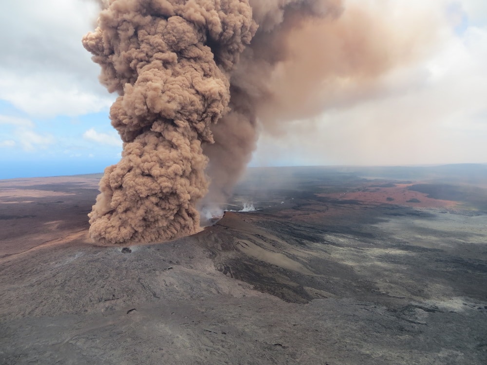
MICHAEL POLAND: I think what was surprising was the fact that the magma went underground so far down the East Rift Zone. Kilauea is composed of a summit complex that has magma stored beneath it, and eruptions can occur at the summit. And in fact, there’s been a lava lake present, more or less continuously, at Kilauea’s summit since 2008. But it also travels underground, through these rift zones. And since 1983, it’s been erupting about 20 kilometers from the summit from this Pu’u ‘O’o vent. And we’ve seen previous bouts of activity where Pu’u ‘O’o has collapsed. And there have been new vents that have formed. But it’s always been within a few kilometers of Pu’u ‘O’o. So what’s unusual about this is that it left that area and went another 15 kilometers or so down the East Rift Zone, unfortunately, into this populated area.
IRA FLATOW: Let’s back up a second, and give us a Volcano 101 of the Hawaiian Islands, and why we have this happening.
MICHAEL POLAND: Right, the Hawaiian Islands are formed by a hot spot, which is a zone of melting in the Earth’s upper mantle. It’s probably fed by a plume of hot material that’s rising from deep within the Earth. And as that– the Pacific plate moves over this relatively stationary hot spot, magma punches through the plate, and you get a chain of islands and sea mounts that forms. And in fact, if you look at a bathymetric map, a map of the sea floor, you can see a chain of islands that start at the Big Island, and then goes all the way back to Midway. They become seamounts, and then all the way back up toward Kamchatka in Russia. So this plume of magma, this hot spot, has been active for at least the last 60 million years or so.
IRA FLATOW: So once the crust moves, then the volcanoes, which were once on top of the hot spot, they move? They become dormant or non-existent?
MICHAEL POLAND: That’s exactly right. The ones that are directly over the hot spot now are the most active. And as these volcanoes are carried away by motion of the plate, they get less and less active. And ultimately, they go extinct. Right now, the newest volcano is Loihi, which is off the south coast of the Big Island of Hawaii. And that will one day become an island and possibly merge with the Big Island. It’s the next volcano in the chain.
IRA FLATOW: Does it erupt also?
MICHAEL POLAND: It does. The last eruption of Loihi was in about 1996, recognized from seismicity that was picked up on the island by on land seismometers. And there were also some submarine expeditions that noted that there were some collapsed features and new lava flows that formed then.
IRA FLATOW: So you’re saying that that new volcano could eventually connect the islands together as it forms? It may. It’s difficult to say. Of course it’s going to happen tens, to hundreds, to thousands of years from now. So hard to say. But if the eruption rate from Loihi is high enough– and of course, Kilauea will continue to extend outward. As Loihi becomes more and more active, it may extend back towards Kilauea, as lava flows go in that direction. So it’s possible that one day, it will merge with the Big Island.
IRA FLATOW: Our number 844-724-8255. You can also tweet us @scifri.
We have seen some magnificent photos of nature at work, the lava lake in the summit of Kilauea, and then how it dropped down 240 yards. What happened there?
MICHAEL POLAND: Right, so you can think of Kilauea as an interconnected plumbing system of magma. The summit area is connected to the East Rift Zone via these underground pathways. And so the lava lake at Kilauea summit was actually connected to the Pu’u ‘O’o eruptive vent. And geologists working in Hawaii had been able to see complimentary changes in height of the lava lake at the two places. So the lava lake at the summit may go down, reflecting some subtle decrease in pressure beneath the summit. And then you could see the eruption rate go down from the East Rift Zone vent from Pu’u ‘O’o.
So what’s happening now is the eruptive vent forms now on a much lower elevation, well down below Pu’u ‘O’o, in terms of its overall height. And so the lava lake at the summit is responding to that, as lava drains into the rift zone to feed this low elevation fissure. So the lava lake at the summit drained, as if someone pulled the plug on a bathtub.
IRA FLATOW: Amazing. And now, you work for the USGS Volcano Hazards Program out in Yellowstone, which is like a volcano monitoring network. You all detected weeks ago that Kilauea was going to erupt. So what signs did it give you, that you knew it was going to happen?
MICHAEL POLAND: Well, we have a lot of different tools that we use for looking at how volcanoes may change the activity in the future, seismicity, how the ground forms, gas chemistry, geologic changes, even satellite data. In the case of Kilauea, over the last few months, maybe starting around March, we noticed that the Pu’u ‘O’o eruptive vent was starting to inflate like a balloon. Magma was starting to accumulate beneath Pu’u ‘O’o, probably because there was less of it that was coming out of the ground. It was sort of backing up.
We eventually started to see the same inflation at the summit. And in fact, you might have seen these amazing videos and photos of lava coming out of the summit eruptive vent and resurfacing the floor of Hanauma Crater, which is the summit crater that this lava lake was sitting within. So these were signs of pressure building beneath both Pu’u ‘O’o and the summit. The whole magma plumbing system was starting to pressurize, because there was more coming into the volcano than was getting out.
And we’ve seen this thing happen in the past numerous times, 2007, 2011. There have been new erupt events that have formed as a result of this. But it’s always been relatively close to Pu’u ‘O’o. In 2011, there was a rather spectacular four and a half day period of lava fountaining, not far from the Pu’u ‘O’o vent. So this one, we expected something was going to happen. We knew from the inflation, from the pressurization of this magma system, that we were going to probably see a new erupt vent. But it’s difficult to forecast exactly when or exactly where that activity will take place.
MICHAEL POLAND: I’m Ira Flatow. This is Science Friday from WNYC Studios.
How finely tuned is your hazard system? I mean, how good are you at predicting, and how far out can you predict?
MICHAEL POLAND: I think a lot of our prediction, or forecasting, is based on pattern recognition, to a certain extent. You could see that in the way that this particular event was dealt with, and recognizing the signs that in the past have led to the formation of new vents. So a lot of it has to do with our experience in certain places. The more active a volcano is and the better monitored it is, the more experience we tend to have. And Kilauea, we have a very good record of continuous monitoring, goes back over 100 years. The Hawaiian Volcano Observatory was founded in 1912, so we have nearly continuous observation since then.
It’s also one of the most monitored volcanoes, in terms of instrumentation. There are seismometers all over the place. There are GPS sensors that detect ground deformation, and tilt meters, continuous gas sensors. There’s a tremendous amount of satellite data. So we can detect these sorts of changes that we’ve seen in the past, that lead to changes in volcanic activity. But it’s still a tough call to figure out exactly the how and the what is going to happen, and precisely when. So those are the elements of prediction that we’re still trying to get a handle on.
IRA FLATOW: Let’s go to Dawn in Huntsville, Alabama. Hi, Dawn.
DAWN: Hi.
IRA FLATOW: Go ahead.
DAWN: I’d like to find out if you believe that the recent earthquakes related to Kilauea’s eruption are going to unsettle the rest of the Big Island, such that the other volcanoes may be at risk of erupting.
IRA FLATOW: Good question.
MICHAEL POLAND: Yeah, it’s an interesting question. There’s a lot of research into triggering of eruptive activity between different volcanoes, or between the occurrence of strong earthquakes and possibly volcanic eruptions. There’s not a strong relation. It appears in some cases, yeah, there can be triggered activity. Oftentimes we’ll see stronger earthquakes in one part of the world trigger micro seismicity in other parts. There have been big earthquakes in the past at Kilauea. In 1975, there was a magnitude 7.7 earthquake. It was not necessarily associated with any major activity in other places on the island, except at Kilauea. There was an eruption earlier that year at Mauna Loa, but that doesn’t seem related.
But at the same time, there was in 1868, a very large, perhaps magnitude 8 earthquake, on the south coast of the island. And shortly thereafter, there was an eruption of Mauna Loa. So this particular earthquake, this 6.9 that occurred on the south flank, it’s probably a bit on the small side to be triggering a lot of activity. But this is why we have such an intense monitoring network on these volcanoes.
IRA FLATOW: Now, this lava flow happened in a populated area. We talk about this with wildfires and floods. Should we rethink about where we’re building things? Or are people going to have a false sense of security? Hey, it spewed itself out. It’s safe to go back and rebuild.
MICHAEL POLAND: That’s probably a danger with just about any natural hazard, flooding, wildfires, tornadoes, hurricanes. And I think, really, we need to just sort of take a logical approach to land use planning. I don’t think there’s any place that’s not going to be subject to some sort of natural hazards. So the key is recognizing what we can do to prevent those hazards from becoming natural disasters.
IRA FLATOW: All right, that’s about all the time we have today. Thank you, Michael Poland, volcanologist at the Yellowstone Volcano Observatory. Thank you for taking time to be with us today.
Copyright © 2018 Science Friday Initiative. All rights reserved. Science Friday transcripts are produced on a tight deadline by 3Play Media. Fidelity to the original aired/published audio or video file might vary, and text might be updated or amended in the future. For the authoritative record of Science Friday’s programming, please visit the original aired/published recording. For terms of use and more information, visit our policies pages at http://www.sciencefriday.com/about/policies/
Alexa Lim was a senior producer for Science Friday. Her favorite stories involve space, sound, and strange animal discoveries.