Thermal Imaging Technology Helps Firefighters See Through Smoke
12:05 minutes
Wildfires are still raging out west, and states are using anything in their arsenals to fight back. This year, for the first time, Oregon’s Department of Forestry is using thermal imaging technology to see through thick smoke to the fires below. The state’s firefighting teams say this technology has been game-changing during this devastating wildfire season.
Thermal imaging technology uses infrared waves to detect heat, and then presents that information visually. These graphics make it possible to see exactly where the fire is moving, which areas are the hottest, and how much is actually burning. This information is crucial to firefighting teams on the ground, who can know with more certainty which areas are safe to enter.
Freelance tech reporter Kate Kaye from Portland, Oregon joins Ira to talk about seeing this tech in action in a plane several miles above the wildfires.
Read more about the response team and the thermal imaging technology in a feature from GeekWire.
Invest in quality science journalism by making a donation to Science Friday.
Kate Kaye is a freelance technology reporter based in Portland, Oregon.
IRA FLATOW: This is Science Friday. I’m Ira Flatow.
Wildfires are still raging out West. And states are using whatever is in their arsenals to fight back. Case in point, this year, for the first time, Oregon’s Department of Forestry is using thermal imaging to see through the thick smoke from fires.
Firefighting teams say this tech is a game changer during this devastating wildfire season. Joining me to talk about this is Kate Kaye, freelance tech journalist based in Portland, Oregon. Welcome to Science Friday.
KATE KAYE: Thanks, Ira.
IRA FLATOW: So tell us, how are things in your neck of the woods in terms of wildfires right now?
KATE KAYE: Well, my neck of the woods has not been touched. I live in Multnomah County in Portland. But very close to here, in the Mt. Hood National Forest, in the Cascades mountain range, all to the East and South, there’s wildfires still raging throughout the state, really.
IRA FLATOW: And you had the opportunity, as I understand it, to go up in a plane above the Oregon wildfires to see how the Oregon Department of Forestry is using thermal imaging. Tell us what that experience is like and what you saw up there.
KATE KAYE: Well, when I first had the opportunity, you know, I was envisioning going up in a plane and seeing down and looking down at fires. You know, in reality, you’re not looking down at anything. You’re seeing thick smoke out the window of a small aircraft.
So the best way to describe it would be flying through potato soup. I mean, that’s what it looked like. We were up through several hundred feet of very thick smoke. There’s so many wildfires burning, and they’re converging that it’s just creating even more smoke than ever right now.
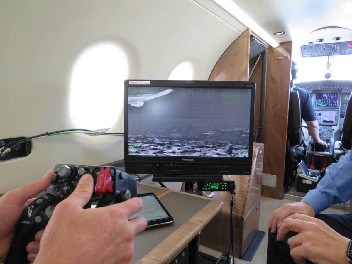
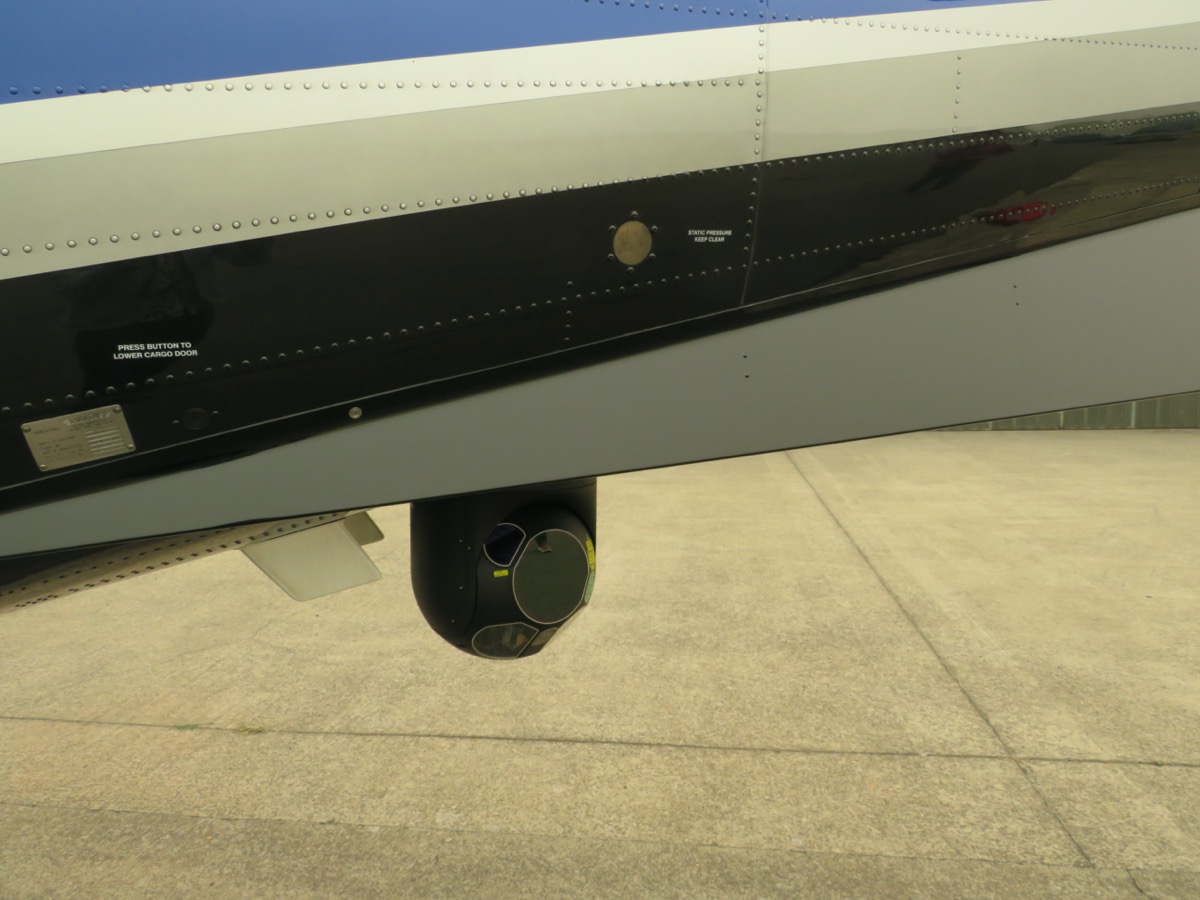
So the thing that I was there to see, though, is inside the plane they have this thermal imaging technology that is actually detecting the heat of the fires below. So it’s visualizing that on a monitor, on a screen like our computer screen in the plane and showing, like, a heat map, the heat signatures of the fires below.
IRA FLATOW: So they’re actually getting thermal images coming in. And it gets translated into pictures that they look at like as hot spots on a screen?
KATE KAYE: Yes.
IRA FLATOW: So what kind of information then are you able to see using this thermal imaging that you can’t see otherwise?
KATE KAYE: Well, I mean, they’re visualizing it. It looks like a grayscale image that shows kind of a glow of anywhere where there’s heat that’s being detected, changes in heat signature that’s being detected. They can get the exact lat-long coordinates of where this heat from the flames is being detected and from where the radiant heat is being detected.
And from a information standpoint, they can actually layer in this information that they’re gathering through this infrared technology on to a topographical map after the fact. Or even in real time, in some cases, the dispatch centers throughout the state are able to obtain this information in real time as somebody is up in an aircraft flying over where the new fires might be spotted, or where a shift in fire is spotted, they can take video or show, hey, I’m over this area right now. And then they could look on a topographical layer, and it would show that it’s burning along a hillside and that it’s near where homes are, for example. So there’s a lot of interesting data that can come out of it.
IRA FLATOW: So they can actually see where the fire is moving and what parts of the fire are the hottest?
KATE KAYE: Yes. So when I was up there, we were up above one of the more massive fires that’s burning right now. It’s the Beachy Creek fire. It’s essentially in the Mt. Hood area to the east of Salem and Portland.
So I was up there with a aircraft operator from Oregon Department of Forestry. And he was looking over an area that he had done the same thing, flying above before that, the day or two before that. He was trying to distinguish what’s changed. How has this fire shifted? You know, that information can be used to determine how to deploy resources on the ground.
IRA FLATOW: And you have a clip with that gentleman for us right now, too, right?
KATE KAYE: Yeah. So his name is Cole Lindsey. He is an Oregon Department of Forestry multi-mission aircraft operator. And he talks a little bit about why this is helpful.
COLE LINDSEY: I get feedback from the people, the operations people and tactical people about what they saw, what they need to see. And so for my end, I feel confident that this is being very beneficial in helping them make a lot of decisions on the ground. Especially because nobody else can see through the smoke right now, it makes it extra, extra beneficial that we could be in this aircraft seeing this thermal image.
IRA FLATOW: That’s interesting. Can you tell us how specifically does this thermal imaging technology help fight the fire?
KATE KAYE: Well, I can tell you how it works a little bit more. So it’s actually using shortwave infrared technology that, again, it detects changes in temperature. And then it visualizes that data in a way that the human eye can see it.
There’s a really interesting aspect of this technology. It uses in algorithmic local area processor. And what that does is it visualizes the variations in temperature. So it actually can distinguish between the heat that’s directly from a flame, or the flames of a fire, and the radiant heat. So if you’re looking at this visual image, you can actually see. Actually, the fire itself is like this amount of surface area, whereas the glow is a lot more.
And there’s actually a really interesting clip from Marshall Gross, who’s a manager of the company that makes this technology, Flir. They’re actually based here in Oregon. And he’s in their applications engineering group. And he describes that.
MARSHALL GROSS: You see the glow of the fire on the ground. And it looks, you know, so big. When you use this local area processor, it will actually identify within that glow where is the hottest point, right? So they can see kind of how much is actual probably fire burning and the rest of that’s radiated heat from that fire.
IRA FLATOW: Oh. That’s interesting. OK. So you have all this thermal imaging up there in the plane. How can the folks on the ground, the fire crews on the ground use this information?
KATE KAYE: Yes. When we flew out of Salem, we actually were in a small aircraft hangar in the Salem airport where the Oregon Department of Forestry is kind of holed up. They have this makeshift command center in there with this whiteboard with all this information showing all of the aircraft resources that they have that are being deployed right now.
And then they have multiple software systems. These systems are able to talk to each other. So they can feed in videos from this thermal imaging technology.
They can take videos and images from the software and then store it for later and use it and incorporate it with the other kinds of information that they have, like I said, topographical maps, where their systems are deployed, where resources are deployed. It can even be used by federal agencies, too. So one of the things that’s happening that’s interesting is that there’s just more data sharing that’s taking place. So it’s not just that this thing’s working like in a vacuum by itself. It’s working in conjunction with a lot of other technologies that are helping give them more information than they’ve ever had.
IRA FLATOW: So even though you’re in Oregon and they’re using it in the Oregon fires, there’s no reason why you couldn’t use it on the California fires, too?
KATE KAYE: Right. So as I understand it, it is being, or at least it has been used. In California, there’s several fire agencies in that state that have used this thermal imaging technology to fight the wildfires.
IRA FLATOW: I understand there’s a good chance we’ll see more of this thermal imaging technology in our lives due to COVID?
KATE KAYE: Yeah, it’s really interesting. The only reason I even knew about this company Flir is because they sell systems that are kind of based on the same thermal imaging. But what they do is they’re body temperature scanning devices.
So you might have heard about these things in airports, or transit hubs, or even in workplaces. I mean, Amazon uses this kind of technology in shipping distribution centers, for example. And the idea is to detect elevated body temperature of people and in a way, understand, hey, this person might have a fever, which is an indicator of COVID-19.
They’ve used this kinds of technology, though, in the past, with the SARS epidemic and the Ebola outbreak. So it’s definitely something that’s actually been deployed all over the world in various places, usually where there’s large groups of people moving.
IRA FLATOW: Yeah. You’ve got to be really good, sensitive enough I, would imagine, to be able to detect the difference in someone’s body temperature from, say, 98 and just 2 degrees, to 100 degrees in a body.
KATE KAYE: There is a lot of, I think, skepticism around the accuracy of that kind of technology, especially when it’s used for a group of people. It can be used in a way that’s a lot more precise. And, like, they’ll have a handheld temperature scanning device that is held up right to– actually measures the heat from your tear duct.
IRA FLATOW: Wow, tear duct?
KATE KAYE: Apparently, the hottest or warmest part of the body is in your tear duct. And so that’s what they’re measuring when they have these hand-held scanners. At least the company Flir, that’s how their system works.
So to me, one of the really interesting questions about all this stuff is kind of the ethical questions around it. Not just are we OK with, when we go to a subway station, or a train station, or work, having our temperatures scanned all the time, but also the fact that the technology that’s used for the wildfires, it’s also used for more controversial things, like law enforcement purposes. It’s used for border security and surveillance.
So I think it’s really interesting to think about that sometimes, you know, technology, it might have a lot of valuable, beneficial purposes that a lot of people don’t question the value of. But then there’s sometimes some other ethical questions that we need to at least recognize that these technologies are used for all sorts of reasons.
IRA FLATOW: Kate Kaye, thank you very much for taking time to talk with us. Fascinating stuff.
KATE KAYE: Thanks, Ira.
IRA FLATOW: Kate Kaye, a freelance tech journalist based in Portland, Oregon.
Copyright © 2020 Science Friday Initiative. All rights reserved. Science Friday transcripts are produced on a tight deadline by 3Play Media. Fidelity to the original aired/published audio or video file might vary, and text might be updated or amended in the future. For the authoritative record of Science Friday’s programming, please visit the original aired/published recording. For terms of use and more information, visit our policies pages at http://www.sciencefriday.com/about/policies/
Kathleen Davis is a producer and fill-in host at Science Friday, which means she spends her weeks researching, writing, editing, and sometimes talking into a microphone. She’s always eager to talk about freshwater lakes and Coney Island diners.
Ira Flatow is the founder and host of Science Friday. His green thumb has revived many an office plant at death’s door.