Pioneering Western Water Management Strategies
23:09 minutes
In the 19th century, the American West was an arid climate yet to be fully explored. But surveyors like geologist John Wesley Powell, the second director of the United States Geological Society, would chart out the natural wonders that lie beyond the Mississippi. While at the USGS, Powell would lead a project to create the first map of the country to integrate geographical features and some of the first survey expeditions along the snaking Colorado River and Grand Canyon. But he also proposed radical ideas about developing the West that took the climate and ecology into account. One of Powell’s theories stated that the U.S. was divided down the middle along the “100th Meridian”—between the dry West region and moist East. In two recent studies, climatologist Richard Seager and his team confirmed this dividing line. Seager joins Ira to explain how this ecological division has changed due to climate change.
[Pando, one of Earth’s largest living organisms.]
And, John F. Ross, author of the book, The Promise of the Grand Canyon: John Wesley Powell’s Perilous Journey and His Vision for the American West, discusses how Powell’s ideas still have relevance in today’s discussions about Western water management strategies.
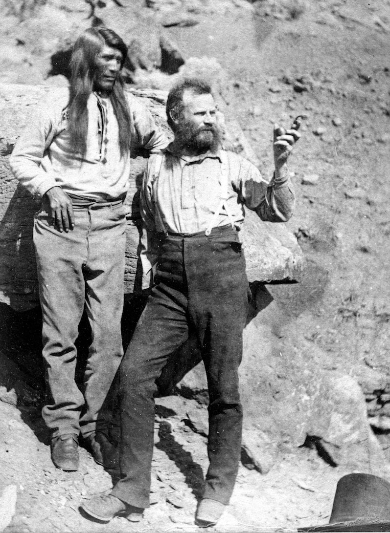
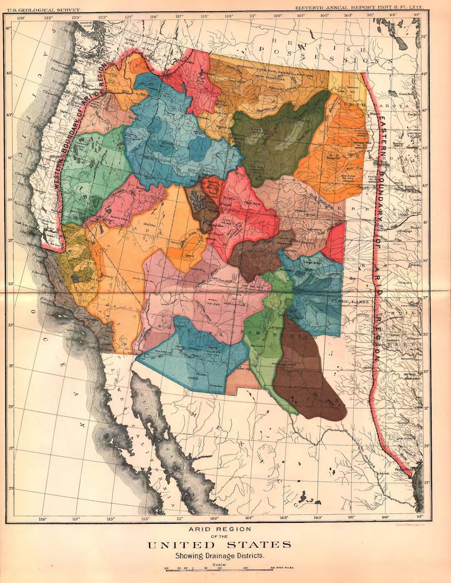
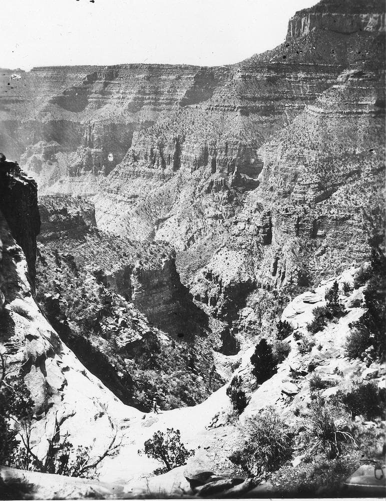
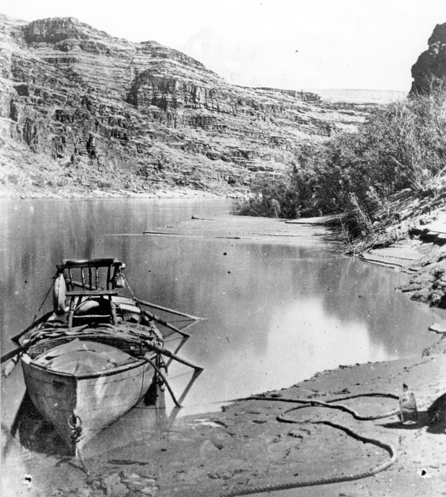
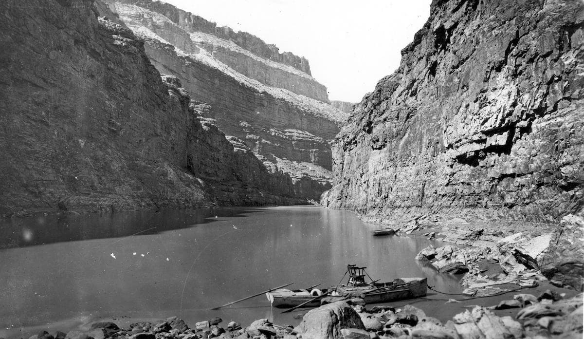
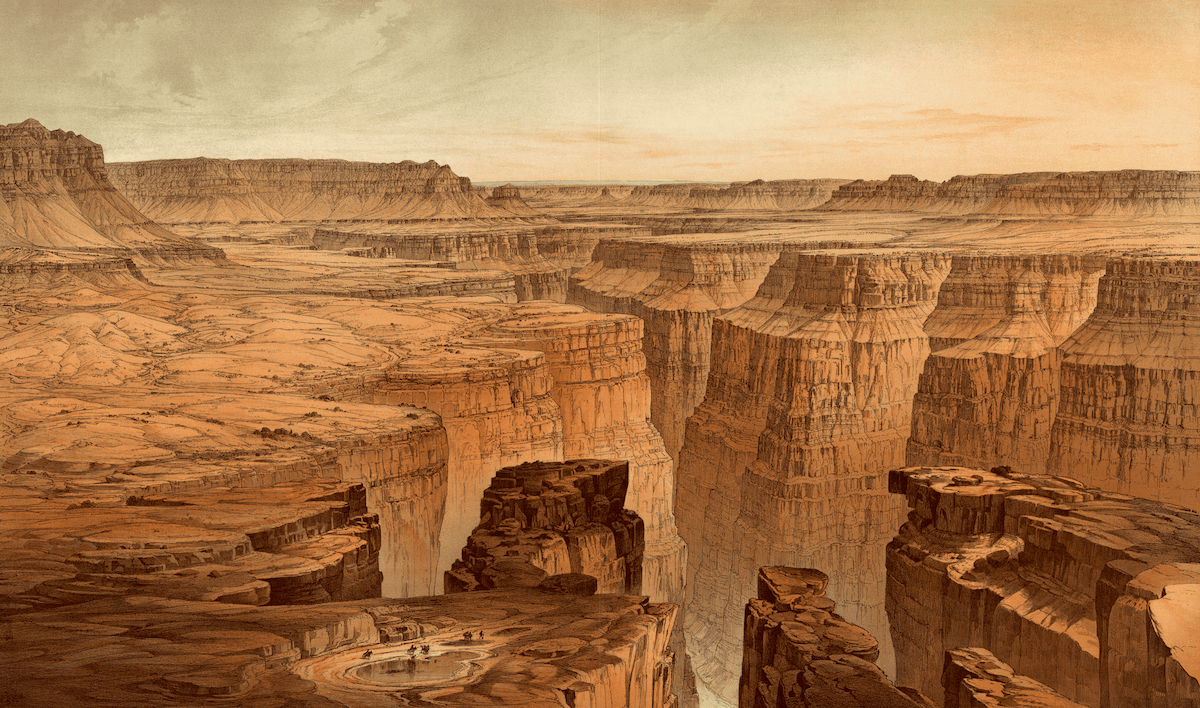
Explore the views of the Grand Canyon and the Colorado River during Powell’s time surveying the American West and his watershed map below. Plus, you can read an excerpt of Ross’ new book here.
[Chasing whales through time.]
[Is offshore wind “picking up steam” on Lake Erie?]
[Drawing Congressional districts is like Sudoku.]

John F. Ross is author of The Promise of the Grand Canyon: John Wesley Powell’s Perilous Journey and His Vision for the American West (Viking, 2018). He’s based in Bethesda, Maryland.
Richard Seager is a professor in the Lamont Doherty Earth Observatory of Columbia University in Palisades, New York.
JOHN DANKOSKY: This is Science Friday. I’m John Dankosky. In California and the Western part of our country, water, or more specifically the lack of it, is a big issue. Supplies have been dwindling due to warming weather and expanding populations.
In the late 1800s while the country was in a rush to expand westward, there was a scientist who warned of a future water crisis in the west. John Wesley Powell was an explorer and a geologist. His proposals seemed radical at the time, but his ideas about water use, climate change, and how science and government mix have lessons we can learn from today.
My next guest is here to talk about that. John F. Ross is author of a new book called The Promise of the Grand Canyon, John Wesley Powell’s Perilous Journey and His Vision for the American West. John F. Ross, welcome to Science Friday. Thanks for joining us.
JOHN F. ROSS: Well, my pleasure, John. Thanks for having me.
JOHN DANKOSKY: And if you’ve got questions, you can give us a call, 844-724-8255. That’s 844-SCI-TALK. If you’ve seen changes to water in the west. There’s so much to talk about, about this fascinating explorer. He would eventually go on to become the second director of the US Geological Survey. But starting off he was he was studying geology in the mid 18th century. John Ross, give us a sense of what geology was like back then.
JOHN F. ROSS: Well, you know back then, geology was the particle physics of its day. Most people thought about Earth’s history, and they were kind of stuck in a biblical idea of it being 6,000 years old. And what geology was beginning to do was turn that on its head and suggest that maybe the Earth was millions and millions of years old. It was this, Charles Lyell’s grand opus of Principles of Geology that opened up the idea for Darwin to think about evolution. But it also started turning everything upside down, and really moved America and the world into a new direction.
JOHN DANKOSKY: And so how did Powell get into this? How did he get interested in geology?
JOHN F. ROSS: You know, he had a mentor, like so many great scientists do when he was a kid in a small Ohio town. And it was this self-taught fellow who discovered in some salt kettles, it was salt licks, he found these great Pleistocene saber tooth tiger skulls and mastodon teeth and all like that. And so this fellow really turned John Wesley Powell. His father, of course, named him John Wesley after the great Methodist, founder of Methodism, and wanted him to be a minister like he was. And John Wesley, the young boy, said no, I’m just really fascinated by geology and what’s beginning to happen.
JOHN DANKOSKY: So let’s talk about this trip that made him so famous down the Grand Canyon. This expedition into this amazing place that so few people had seen. How did he come to make that trip?
JOHN F. ROSS: Well, it’s a really interesting story. So he had studied some geology, didn’t graduate from college, he was a principal in a Midwestern school, but it was an incredible burning curiosity. And he took some of the first college field trips out west, out to Colorado, out to Middle Park and South Park to collect for institutions.
And he heard about– at that point, just after the Civil War when he would do this very famous expedition, there was only one little patch of continental America that was left unexplored, unmapped, 100 by 300 mile section of the Colorado Plateau. And of course, it includes today’s Bryce Canyon and Zion and of course, the Grand Canyon that Powell would name. Very, very inhospitable to people, but Powell saw, as a geologist that there was this extraordinary opportunity to go through the river, which nobody knew what happened to the river, whether there were falls, whether it went underground, he had recorded reports of that, or really what it was. And he thought, wow, here’s an incredible opportunity for a scientist to go into one of the greatest gashes in the world and figure it all out.
JOHN DANKOSKY: Of course, there’s so many stories in your book of exploration, which is what draws so many people his story. But what were some of his scientific observations of the Grand Canyon?
JOHN F. ROSS: Yeah, so that’s really interesting, John. So most people know him about– it’s this incredible tale. He lost an arm during Shiloh. So he’s a one-armed guy. He takes nine guys in these puny rowboats down through these incredibly awful rapids and through unexplored. I mean, it’s very dramatic. But what that has hidden over the years is the fact that, as I was saying, here’s this geologist, it’s like one of the most incredible scientific opportunities of the 19th century. It was like a kid in a candy store going down. So he would go down.
The other guys were these adventurers. They looked up and they saw colorful rocks. But what the rocks were telling Powell were these incredible stories. He would see, because as you start, at Lee’s Ferry for instance, and you can start into the Grand Canyon like I’ve done, you start with a kaibab limestone. It’s 250 million years old triassic rock, kind of creamy.
And as you go down the next couple of hundred miles, you go down and down and down and you go through 19 different rock strata. And the kaibab limestone eventually is 6,000 feet above your head, and you reach the Vishnu Schist, this really dark, hard rock, and it’s the basement rock they call it. It’s nearly two billion years old.
And so he was really literally going back in time into the Earth. He called it like reading a book. He said, as we went, I read. So he would see these alternating layers of limestone and sandstone that kept alternating, and what he saw there was this great inland sea that was receding and coming back and receding. He saw this, but he also saw these puzzles. He saw this split mountain, this incredible mountain, and the river, Green River, at that point goes right through the middle of this, right through the middle. It’s like you take a bandsaw through 10 miles of this high mountain and cut it right in half. And the river went right through there.
And Powell looked at that and said, well, why didn’t the river just go around? Why did it go through this mountains? So he started asking these questions. And so he started coming up with ideas about whether the river went first, whether upthrust went first, and he started basically and invented and gave word to the science of geomorphology, which is the whole science of Earth’s topographic features and how they’re changed through geologic processes.
JOHN DANKOSKY: So did this change the public perception of what the Grand Canyon was and how it came to be?
JOHN F. ROSS: You know, it’s so interesting you asked that, John, because people have seen the Grand Canyon for a long time, the conquistadors centuries earlier, the Spanish conquistadors had come in and taken one look at it and gone, whoa, this is a place nobody is ever wanting to go and nobody ever should go. It scared them.
And right up until Powell’s time that was pretty much what people thought, this was not a place. And Powell’s real genius was to start talking about the geology, to start talking about how beautiful it was, and how extraordinary it was. He brought artists out. He brought photographers on his trips. And he began to change the whole public perception of this big huge hole in the ground, until it has become today, as we know, one of the most iconic features, part of American exceptionalism, part of what really makes America so special.
JOHN DANKOSKY: But he had very different ideas about how America was expanding and how it should expand than a lot of other Americans. Can you talk a bit about that? About how he felt America should be moving toward this great unknown territory?
JOHN F. ROSS: He was a man of his time. This was a country right after the Civil War. People had put down their arms and they were getting back to the business of building up America again. And all eyes turned to the American West. It was largely undeveloped, little known, and so what were people going to do with it? Well, for the vast majority before the Civil War, explorers had dubbed it the Great American Desert. It was too dry out there, really, a lot of people thought that America ended with the Rocky Mountains kind of thing.
And there was a big turn around with manifest destiny, railroad boosters, all of this. Suddenly, there was talk about how the land out there was an Eden, and how immigrants and people could seek their fortune. And this was America. You just have to go out there and take your plot of land and everything would be great.
Powell said, who had spent so much time out there thinking about all these things said, hey, wait a minute. I’m all for developing America to its great potential, but there’s not enough water out there among other things.
JOHN DANKOSKY: He re-imagined how borders of states should be drawn based on his findings, developing an idea of watershed district. Something very different than the way we actually developed. What were some specifics of his plan, if you could?
JOHN F. ROSS: Well, it’s interesting. So as head of the US Geological Survey, which he really developed, he had his cartographers draw this map, which he presented to the Senate. And it’s a really colorful thing. It looks like if you took a paint ball with different colors and you hit the map of the American West. And what he was indicating there were watersheds. And his whole idea was that water should be kept in the watersheds. And that this, and that local control of water should be kept within by the small farmers, by the local people.
And this was an extraordinary, revolutionary idea, because when you look at the map, most people thought of a map as political lines and boundaries. It had an effect that was somewhat akin to the early pictures of the Earth in the 60s when the astronauts brought home those pictures of the Earth as a fragile orb. It really kind of imagined what America was about in an entirely different way, an entirely different lens.
JOHN DANKOSKY: We’re talking with John F. Ross. He’s the author of a new book called The Promise of the Grand Canyon. John Wesley Powell’s perilous journey and his vision for the American West. If you’ve got questions, 844-724-8255.
Another idea Powell came up with was the 100th meridian, based on his observations theorizing the country split into different regions based on climate. He drew an imaginary line right down the middle, starting on the Western side of Minnesota going straight down through East Texas. A group of researchers wanted to test if Powell’s boundary was real. They published the results back in March.
Richard Seager is here to tell us what they found. He’s an author on that study, and a professor at the Lamont-Doherty Earth Observatory of Columbia University, Palisades, New York. Richard, welcome to Science Friday.
RICHARD SEAGER: Hello.
JOHN DANKOSKY: Thanks so much for joining us. So I learned about this idea– the 100th meridian back in school. What is the significance of it to a climatologist?
RICHARD SEAGER: Yeah, well it was interesting. I have been working on problems related to climate and water in the west for several years now. And of course, I’ve read Powell’s work and read about Powell. And being very aware of his idea that the 100th meridian divided America into an arid west and humid east. And you learn that in high school, and it’s very well established in the way Americans think about the country. It’s kind of part of their psycho geography really.
And we wanted to test whether the concept was really grounded in reality. How it was that the climate system established such a stark boundary, and whether that stark boundary can really be seen in the landscape and soil moisture, in vegetation. And then also whether it could influence the development of the West. Whether you could find a trace of the 100th meridian and the division in terms of how agriculture is practiced in the country and also in population density and the agricultural economy.
So that’s what we did in those couple of studies. And we found that Powell was very much correct that there is a very stark dividing line in the middle of the Great Plains. And he might actually have chosen 98th meridian as a more accurate, but clearly the 100th was going to stick in the popular imagination in a way that the 98th wouldn’t.
JOHN DANKOSKY: I just want to say, I’m John Dankosky. This is Science Friday from WNYC Studios. We’re talking with Richard Seager right now. So continue your thought, Richard.
RICHARD SEAGER: And the climate system does establish this boundary. And that’s like a combination of the way the atmosphere moves moisture around. It’s very well reflected in the type of vegetation that would be there naturally. And then we found that the way that agriculture and settlements has developed has been very reflective of the 100th meridian.
So while the previous speaker, John, was talking about how Powell argued for a very conscious way to develop the land, he of course, was ignored in that regard. And the way the land was developed went ahead without paying too much attention to the environmental constraints that existed. What happened is that those environmental constraints made their selves known anyway. And if you look at the agricultural economy, you find that the corn that is grown is pretty much restricted outside of Nebraska to the east of the 100th meridian, whereas west is where all the wheat and range lands are.
And you also find much larger farms to the west because of the lack of lower productivity of the land, and far fewer farms as well. So you see how the aridity divide that Powell talked about did and in the end, 150 years later we know now, have a very strong impact on the settlements and economy of the nation.
JOHN DANKOSKY: Is this line moving further eastward all the time
RICHARD SEAGER: Yeah we did look at that. The really good data on this only goes back to about the 1979s. But over the last 30 something years it has moved eastward by about 150 miles kind of thing. And we looked at model projections of the future, and we see this arid, humid divide continuing to move eastward over the current century. And that’s a consequence of rising temperatures, which take more moisture out to the surface, increasing aridity.
And in the southern plains, also a decline in winter precipitation in the Western plains as well. So it’s two processes combining, such that the aridity continues to move eastward as the century progresses. And we would predict that that will have to have some consequences in agriculture as well. That just as agriculture has adapted to the environments over the past 150 years, it will continue to [INAUDIBLE] with that– to the changing conditions in the future. So corn would become increasingly restricted to the east. Wheat and range lands would expand eastwards as well.
JOHN DANKOSKY: We’re talking with Richard Seager, professor at the Lamont-Doherty Earth Observatory of Columbia University, Palisades, New York. And also with us is our guest, who’s written this really interesting new book about John Wesley Powell. It’s called The Promise of the Grand Canyon, John F. Ross.
When we come back, we’re going to take some of your questions at 844-724-8255, that’s 844-SCI-TALK, as we talk about the Grand Canyon in the arid west, and the dividing line between east and west in America. How we use water. That’s coming up next.
This is Science Friday. I’m John Dankosky. We’re talking this hour about the 19th century explorer and geologist, John Wesley Powell with my guest, John F Ross, who’s the author of the new book The Promise of the Grand Canyon, John Wesley Powell’s Perilous Journey and his Vision for the American West. Also joining us is Richard Seager, professor at the Lamont-Doherty Earth observatory of Columbia University.
Before our break, John we were talking with Richard and he said that the ideas that he brought to the table, that Powell brought to the table, were largely ignored at that time as far as how we should organize ourselves. What did that mean for the way that America developed over time, John?
JOHN F. ROSS: Well, it’s kind of the peril of the visionary. And he was a very practical man, but he finally got shut down by Western senators. And of course, 30 years after his death we have the incredibly awful environmental tragedy of the black dusters– the Dust Bowl that blew away all the topsoil from over plowing.
The topsoil, there was so much in the air, that it moved as a cloud, 1,000 miles west and hit the east coast in 1934 and 1935, begriming windows. Clouds 10,000 feet tall, and it came into the capitol most notably, where the senators were talking about what to do. And it was a very powerful ambassador, this dust cloud, because it caused them to really begin, in an interesting way, to listen to Powell, to talk about putting together soil conservation service to start growing new trees and windbreaks. And really begin to talk about the thing that Powell had talked about, was the dynamism between Earth, human activities, and climate.
JOHN DANKOSKY: Richard Seager, do you have a sense of how you think things may have changed if Powell had been listened to back in his day?
RICHARD SEAGER: Well, I think the powerful message that he had was that when you are developing a harsh environment like you have everywhere west of the 100th meridian, you have to pay very careful attention to the land, the soils, the vegetation, the water, because they do represent a real limit. And you can either do that in and anticipatory way and plan for it, or you can do it as a crisis management situation.
And we’re still seeing, in the west on a daily basis, the results of not paying attention to what Powell recommended in that we deal with one crisis after another. There were water crises all the time. The crisis that we’re having every summer now with these chronic forest fires that are endangering inhabited areas as people expand into areas that are at high fire risk, and climate change is making fire risk grow.
So with the issue back in the Plains and agricultural adaptation, again, we can look ahead and anticipate how climate is going to change and how that will make different parts of the Plains more or less viable for different crops and plan. Or we can just wait for the inevitable crises to happen and deal with it after the effects. But if we deal with it afterwards, we’re going to be dealing with a lot more human suffering than we would have to deal with if we planned in advance.
JOHN DANKOSKY: I want to thank Richard Seager, professor at the Lamont-Doherty Earth Observatory of Columbia University, Palisades, New York. Thank you so much, Richard. I appreciate it.
RICHARD SEAGER: Thank you. You’re very welcome.
JOHN DANKOSKY: I want to read, John Ross, just a brief passage from near the end of your book where you write that Powell anticipated the tragedy of the commons. This is what we were just talking about. An economic theory coined nearly 80 years later.
You write, “When a group wins access to a resource held in common pasture, for instance, fish in the sea or water in arid lands, a distinct pattern emerges. The overall effect of individuals left free to act independently leads to over exploitation and often the destruction of the entire resource.” This seems to be something that is playing out not just in Powell’s day, but over and over again throughout American history.
JOHN F. ROSS: Absolutely. I mean, you just consider the Colorado River itself. It used to go into Mexico on its way out to the ocean, and now there’s just dry land there. Every drop of the Colorado is owned and taken by one group, one state, or another. And he just hit it right on the mark on that. And it was something that nobody wanted to listen to.
But I think also, John, that what some of the lessons here, too, are why people didn’t listen to him then. Or the same reasons why some people are not listening now to some of what climate change scientists are having to say. And I think it really, at the bottom line, it has to do with people thinking that talking about these issues, talking about ecology, talking about sustainability, will get in the way of American progress. That it’s like a wall in the way. And Powell’s big thing was, no, it’s not. This is actually the path toward progress.
JOHN DANKOSKY: And he was not someone who wanted to stop progress, right? He wanted to build out the west.
JOHN F. ROSS: Oh, absolutely. No, he was in favor of dams and all sorts of things. And he had all kinds of ideas about changing the land, and making it– but I think he would have been horrified by the mega dams that came after he died.
JOHN DANKOSKY: We’ve run out of time for our segment. But I want to thank our guests, John F. Ross. He’s the author of his new book, it’s called The Promise of the Grand Canyon, John Wesley Powell’s Perilous Journey and his Vision for the American West. You can read an excerpt of that book on our web site, sciencefriday.com/grandcanyon.
John, thank you so much for the book and for joining us. I appreciate it.
JOHN F. ROSS: My pleasure, John. It was fun.
Copyright © 2018 Science Friday Initiative. All rights reserved. Science Friday transcripts are produced on a tight deadline by 3Play Media. Fidelity to the original aired/published audio or video file might vary, and text might be updated or amended in the future. For the authoritative record of Science Friday’s programming, please visit the original aired/published recording. For terms of use and more information, visit our policies pages at http://www.sciencefriday.com/about/policies/
Alexa Lim was a senior producer for Science Friday. Her favorite stories involve space, sound, and strange animal discoveries.